Daniel Salzler No. 1161
EnviroInsight.org Four Items August 5, 2022
—————Feel Free To Pass This Along To Others——————
If your watershed is doing something you would like others to know about, or you know of
something others can benefit from, let me know and I will place it in this Information newsletter.
If you want to be removed from the distribution list, please let me know.
Please note that all meetings listed are open. Enhance your viewing by downloading the pdf file to view photos, etc. The
attached is all about improving life in the watershed. If you want to be removed from
the distribution list, please let me know. Please note that all meetings listed are open.
Check our website at EnviroInsight.org\
1. Really Understanding Your Water Consumption Per Person .
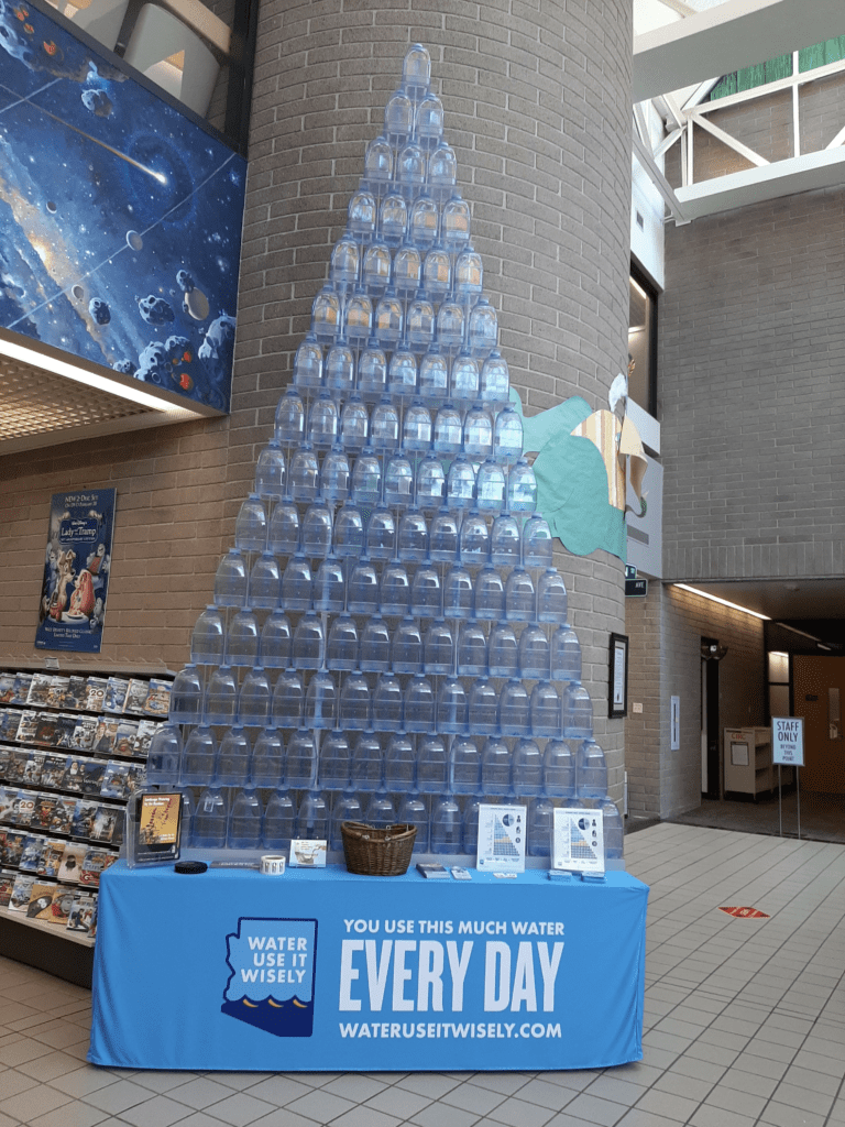
This is how much water you use every day.
Can you make your “tree” smaller?
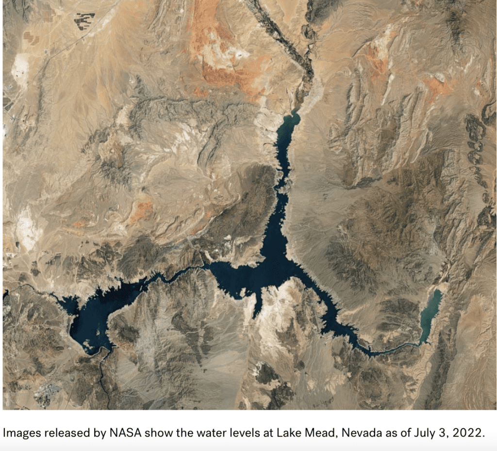
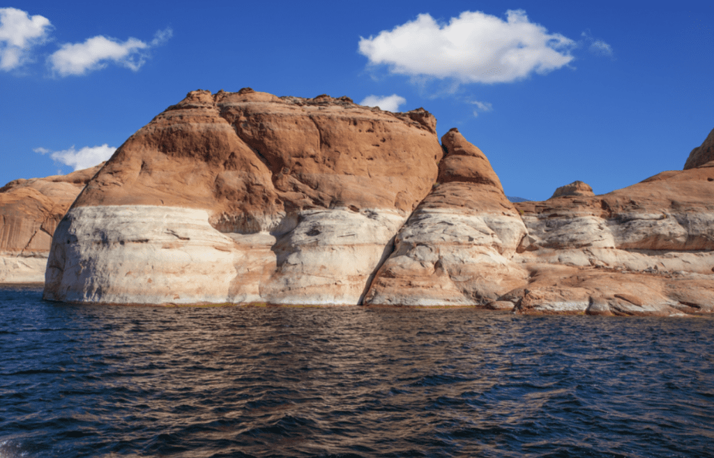
2. Lake Mead. Lake Mead’s water levels have fallen to 1,040 feet, inching ever closer to dead-pool level.
Lake Mead, a reservoir formed by the Hoover Dam on the Colorado River, has been drying up because of the ongoing drought in the western United States. It stretches across Nevada and Arizona.
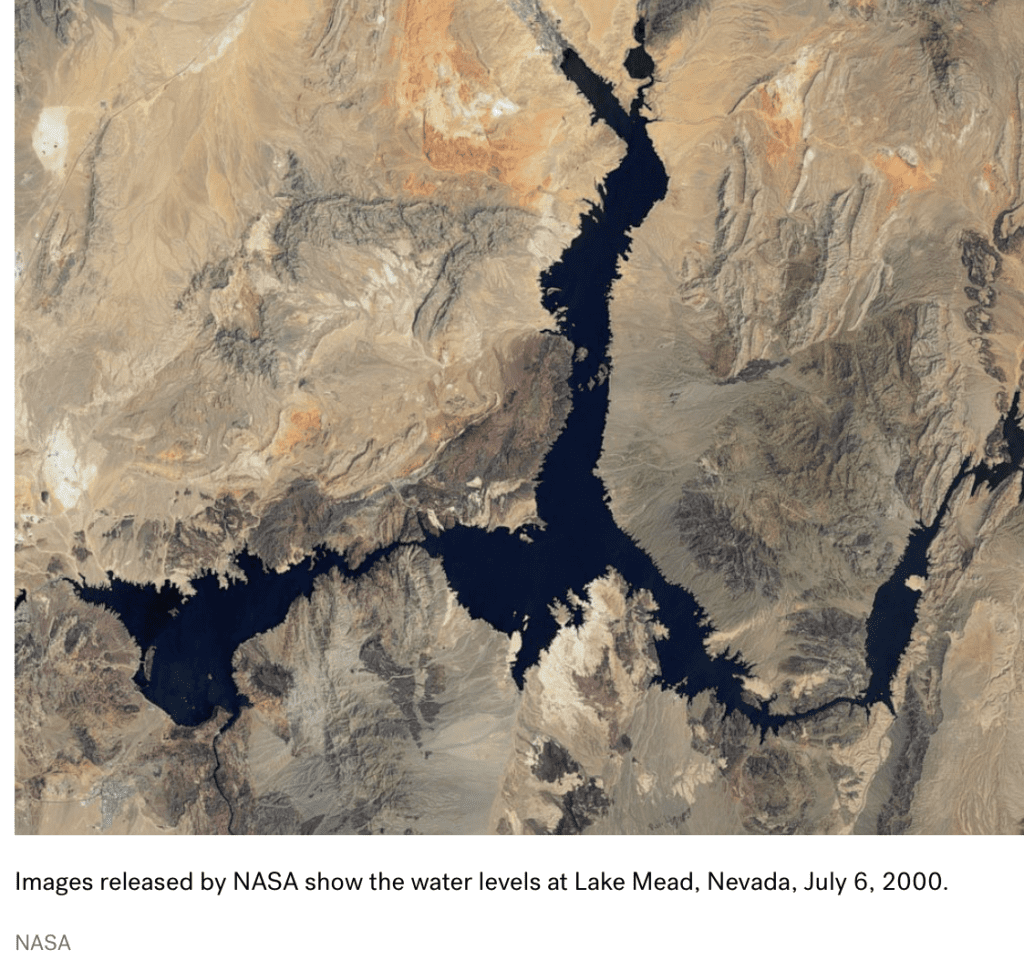
According to new data from Lakes Online, as of July 28 at 4 local time, Lake Mead had fallen to 1,040 feet. At the beginning of 2022, the Lake was at 1,066 feet.
The levels have rapidly decreased over the last couple years. In the beginning of 2020, levels were at 1,090, while at the beginning of 2021, levels were at 1,083.
The water moving through the Hoover Dam provides electricity for hundreds of
thousands of people living around the area. However, as the drought continues and the water continues to dry up, there is a danger of the dam’s turbines no longer being able to generate power.
As the lake continues hurtling towards dead-pool level, experts remain concerned.
The minimum surface elevation needed to generate power at the Hoover Dam is 1,050 feet, according to the U.S. Bureau of Reclamation. Anything below that is considered an “inactive pool,” and a “dead pool” exists at 895 feet in elevation.
“If it got to that point, water levels could still drop due to evaporation,” McAfee said. McAfee said also said “there’s good evidence to suggest that climate change is playing a role.”
“A number of scientific papers have found that rising temperatures are reducing the amount of water flowing down the Colorado River and into Lake Mead. There were a couple of papers by Parks Williams and colleagues suggesting that climate change is not quite half the contribution to this drought. That research noted that it would still have been a drought without higher temperatures, just not as bad,” she said.
According to the U.S. Drought Monitor, more than 20 percent of land in the western U.S. was determined to be in an “extreme or exceptional drought,” as of March 8, 2022. The last time Lake Mead’s water levels were this low was in 1937.
While it is not the only body of water being affected, Lake Mead has caught global attention due to the mysterious discoveries being made, as the water continues to evaporate.
In May, as the Lake’s bottom became exposed, human skeletal remains were discovered at the bottom of a barrel. The remains were believed to be a shooting victim from the mid-1970s or 1980s.
Another set of human remains were also discovered earlier this week. Source: Newsweek and abc News
3. CAWCD Board Holds Special Meeting To Discuss Deteriorating Colorado River Conditions. Camille Touton, Commissioner of the Bureau of Reclamation, testified before the U.S. Senate Committee on Energy and Natural Resources. In that testimony, she acknowledged that the challenges we’re seeing today are unlike anything we’ve seen in our history, stating that in addition to the actions that are already underway, between 2-4 million acre-feet of additional conservation is needed in 2023 just to protect critical levels in the major reservoirs (Lake Powell and Lake Mead) that allow for water delivery, power generation and infrastructure stability.
Touton said that although it is within Reclamation’s authorities to act unilaterally to protect the system, she first wants to pursue a path of partnership and collaboration, and gave Colorado River Basin States parties until the August 24-month study to agree on a course of action.
You can read a statement about this announcement from CAP General Manager Ted Cooke here.
As a result of these deteriorating conditions on the Colorado River system, the Central Arizona Water Conservation District (CAWCD) Board held a special meeting on Monday, June 27. CAP Assistant General Manager of Water Policy Patrick Dent made a presentation on the current hydrology and basin status.
Similar information was also shared at a June 23 CAP Water User’s Shortage Briefing. That presentation and video is posted on CAP’s website.
We will continue to share relevant information through Know Your Water News via these “River Updates” throughout the fall and beyond, as necessary.
4. Upper Agua Fria Watershed Partnership. As prudent stewards of the upper Agua Fria Watershed – which provides beauty bouncy and sustenance- we envision sustainable, multi-generational future of health and continued abundance achieved through best-practice management of this semi-arid and watersheds natural system.
Mission Statement
The Upper Agua Fria Watershed Partnership provides a regular forum to engage diverse stakeholders proactively to develop, discuss, and coordinate
• relevant objective information
• collective work projects and
• best-practices management policies concerning the holistic, long term health of the watershed’s natural systems in the context of demographic and ecological change.
Water Quantity Goals
One overarching goal is to understand and better quantify the Water Budget (How much water is available and how much is being used?) The goals below can be used to evaluate components of the water budget the goals are not necessarily in order of priority.
Goal # 1: Determine how storage changes.
Task 1: ADWR Well Sweep for groundwater levels interpretation of well sweep data. Evaluate future needs
Task 2: Micro gravity survey
Goal # 2: Understand Precipitation (gages).
Task # 1: Inventory gauge system infectiveness (Evaluate e.g. are we getting the correct information? Do we need others?)
Task # 2: If others are needed make, (and implement) plan for new gages.
Goal # 3: Understand pumpage.
Task # 1: Determine current water-use trends (collect and compile data and analyze for trends.)
Goal # 4: Understand surface water system (variation, diversions, baseflow, inflow/ outflow).
Task 1: Compile and evaluate data.
Task 2: Evaluate need for additional surface water gages.
Task 3 Install new surface water gage (if justified and funded)
Goal # 4: Recharge. Comment: Recharge is difficult to quantify.
Goal # 5: Water conservation and education,
Task 1: Coordinate and cooperate with coalition
Task 2: Obtain and evaluate data on water-use (see goal three)
Water Quality Goals
Goal# 1: Identify prioritize and document water quality concerns throughout throughout the upper Agua Fria Watershed and positively influence the future visions for for water use designations consult ADEQ (Arizona Department of Environmental Quality) from present designations (NEMO report).
Goal # 2: Stay abreast of issues surrounding water quality such as erosion/’ stream bank stabilization methodology, dumping, plant and animal pest management, septic system management, livestock water management, riparian zone management.
. Goal# 3: Investigate use of computer modeling with the help of the information gathering GIS (geographic information system-check with NRCS). CTIC (conservation technology information center) publications may be helpful. See www2.ctic.purdue.edu/KYW/Brochures/PutTogether.html
Goal #4: Investigate water quality parameters for regular monitoring at various sites throughout the Upper Agua Fria Watershed, such as Nitrates, Phosphates, PH, Bacterial/Biological Surveys, Vegetative Surveys, Turbidity
Goal # 5: Establish specific objectives and encourage management alternatives based on water quality trends. For example, cleaner water can be obtained by doing “X” because we have documentation of declining quality due to “Y”.
Goal # 6: Create opportunity for a participation and interaction (education) in the Upper Aqua Fria Watershed through clean-ups, workshops, field days/tyours, guest speakers, celebrations
Watershed Health Goals
Goal # 1: Identify and appraise the general condition of watershed uplands and their major components by Geomorphic, Geologic, Soil and Vegetation, and land use criteria-in relation to its hydrologic function.
Goal # 2: Identify and appraise the conditions of the riparian areas and how they are functioning. Are there trends in habitat conditions that warrant further study or management actions.
Goal # 3: Identify and appraise the probable general effect of existing and expected land uses on flood flows and sediment production.
Goal # 4 Identify and appraise the watershed conditions and existing and expected land uses to maintain the water production of the watershed in terms of groundwater recharge and base flow. In particular, what are the likely general effects of urbanization?
Goal # 5: Identify and appraise the areas particularly vulnerable to watershed damage – both onsite and downstream – from potential wildfires.
Climate Change Goals
Goal # 1: Identify and study the most reliable scientific resources concerning the most likely effects of climate change and watershed functions in Arizona and the upper Agua Fria
Goal # 2: Identify local trends which may be observed measured and monitored in the watersheds various bio-vegetation zones which may be indicative of climate change. For example: invasive species, black beetle, etc.
Goal # 3: Develop best case and worst case scenarios for climate change for the UAF.
Planning Goals
Engage (participate, dialogue?) in comprehensive federal state county and community land based planning efforts throughout the Agua Fria Watershed and pursuit of a UAFWP vision and mission. Asprudent stewards of the upper Agua Fria Watershed the partnership will advocate best management practices for current and future operations.
2022 Issues
Solar Farm north of Cordes Junction
Kay Mine in Black Canyon City
Pioneer Gravel in Mayer
Agus Fria Riparian Protection
1200 square miles from Crown King to Lake Pleasant since 1999
earthhouse@aol.com 480-206-8228
Meets monthly, first Tuesday
Copyright: EnviroInsight.org 2022