
Daniel Salzler No. 1368 EnviroInsight.org Five Items July 24 2026
—————Feel Free To Pass This Along To Others——————
If your watershed is doing something you would like others to know about, or you know
of something others can benefit from, let me know and I will place it in this Information .
If you want to be removed from the distribution list, please let me know.
Please note that all meetings listed are open.
Enhance your viewing by downloading the pdf file to view photos, etc.
The attached is all about improving life in the watershed through knowledge.
If you want to be removed from the distribution list,
please let me know. Please note that all meetings listed are open.
Check our website atEnviroInsight.org
- Super El Niño? What Could That Mean For The Colorado River?
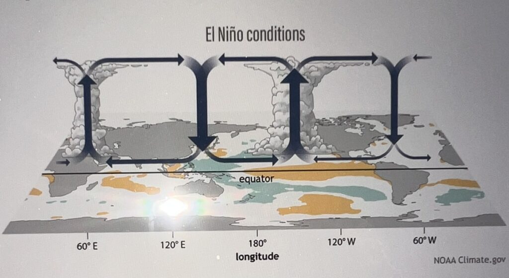
El Niño is often portrayed as a predictable event that has the same effect whenever it appears. In reality, however, the effects of El Niño are not guaranteed, and this winter’s competing oceanic and atmospheric cycles are a perfect example of that. Context matters – none of these cycles is happening in isolation and the way in which they interact can make or break expectations.
So, let’s break it down by looking at the ocean, the atmosphere – and the complicating factors.
What happens in the ocean during El Niño?
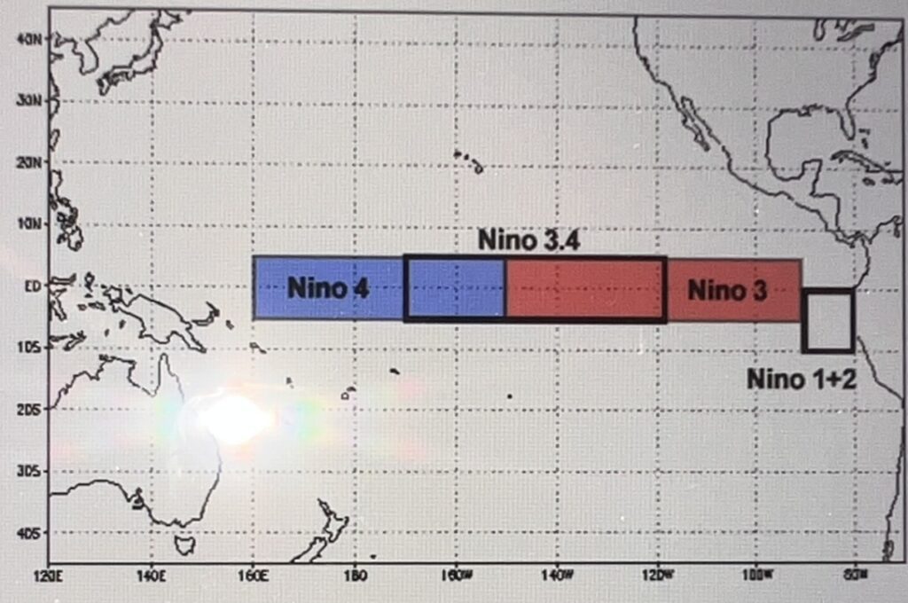
El Niño is a seasonal pattern: it persists over several months. Defined by the trend in sea surface temperature anomaly (SSTA, or “how different current temperatures are from the long-term average”) in the “El Niño 3.4” region of the Tropical Eastern Pacific Ocean, it is primarily an oceanic phenomenon.
What happens in the atmosphere during El Niño?
In what we think of as a “classic” El Niño, the atmosphere syncs up (“couples”) with the ocean. The tradewinds weaken and may even stall, stranding a mass of warmer-than-average surface water along the Equator in the eastern Pacific. The cycle the tradewinds follow across the equatorial Pacific is known as the Walker Circulation (Figure 2). In a “classic” El Niño, this entire pattern shifts eastward.
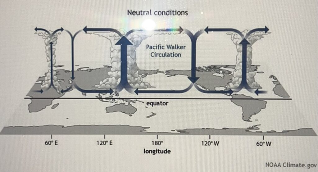
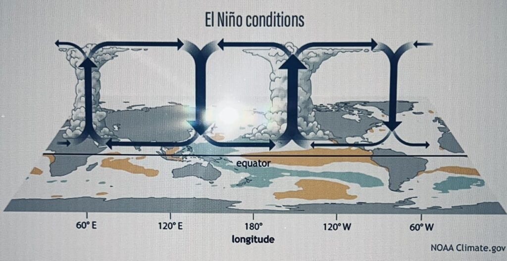
Figure 2 – The Walker Circulation in “neutral” (top) and “classic” El Niño conditions (bottom) (https://www.climate.gov/news-features/blogs/enso/walker-circulation-ensos-atmospheric-buddy)
What makes this year a “Super El Niño”?
The designation of “Super El Niño” has partly to do with the expected magnitude of the shift in SSTA, but also with the expected speed of that shift. If predictive modeling shows an expected change in SSTA of less than +2.0°C, then the event is deemed an “El Niño” (Figure 3).
If predictive modeling shows an expected change in SSTA greater than +2.0°C, however, then the event is deemed a “Super El Niño.” (Figure 4).

What can we expect from El Niño?
Classic El Niño years have historically meant wetter winters for the Southwest and warmer, drier winters for the Pacific Northwest and northern continental US. (Figure 5).
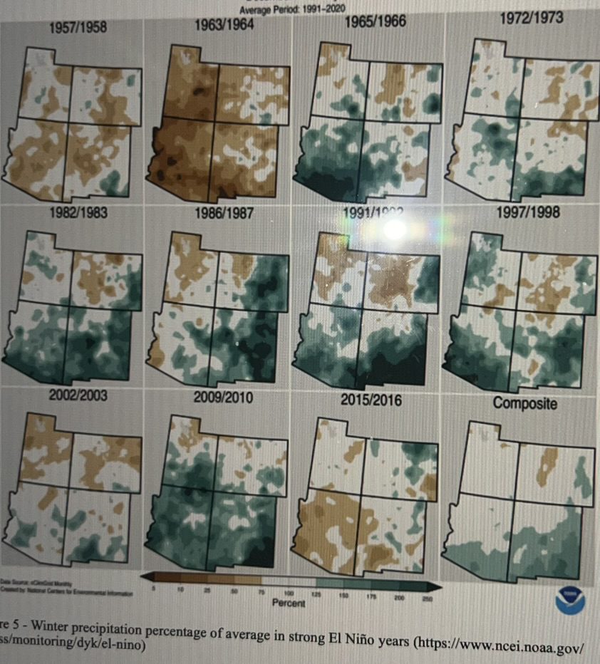
Figure 5 – Winter precipitation percentage of average in strong El Niño years (https://www.ncei.noaa.gov/access/monitoring/dyk/el-nino)
However, judging from the occasional “drier than average” winters in the Southwest shown in Figure 5, El Niño is complex and its outcomes are not guaranteed. This may be due to other complicating factors. Other phenomena that may have an effect on El Niño include:
- Ocean temperature trends – This year’s El Niño is occurring amongst record high average ocean temperatures worldwide (Figure 6). In past decades, the El Niño signature was easier to differentiate from its surroundings, which drove what we think of as the “classic” pattern. Without a significant difference between El Niño and its surroundings, however, the ability of a coupled ocean/atmosphere to move energy and mass where it needs to go on the globe is hampered.

2. Related to the rise in global average sea surface temperatures, a group of scientists recently determined that a warming trend spread throughout the entire Pacific Basin (“Pacific Pan-Basin Warming”) correlates strongly with regional SSTAs. In a recent article in the journal Nature (https://www.nature.com/articles/s41558-025-02482-z) they make a case for this basinwide signature as a primary driver for SSTAs, especially in the past 12 years. This phenomenon would also make the El Niño signal harder to discern.
3. The picture is further complicated by a phenomenon called the Madden-Julian Oscillation (MJO). Currently active, the MJO is an eastward traveling low/high pressure system that arises in the Indian Ocean off the coast of Africa. Unlike El Niño, the MJO does not stand still. It’s a short-lived system of intra-seasonal variability that circumnavigates the globe on roughly a 30- to 60-day cycle.
The MJO matters because, depending on its position, it has the power to either suppress or enhance atmospheric convection in the Eastern Equatorial Pacific. As it enters the Pacific from the west, the downward flow on its eastern end can counteract or even temporarily cancel El Niño (in this case: its “destructive phase” with respect to El Niño).
On its journey east, however, the upward convection typical of the MJO may eventually overlap with the convection caused by El Niño (the “enhancing” phase), charging the atmosphere over the Eastern Pacific with heat and moisture.
4. Changes in the Polar Vortex also have the potential to wreak havoc on the jet stream. The Polar Vortex is a circular band of winds in the stratosphere (the extreme upper atmosphere, far above the zone where weather that affects Earth’s surface is typically generated). Normally, the Polar Vortex flows counterclockwise in a tight, well-organized (i.e. “strong”) manner (Figure 7).
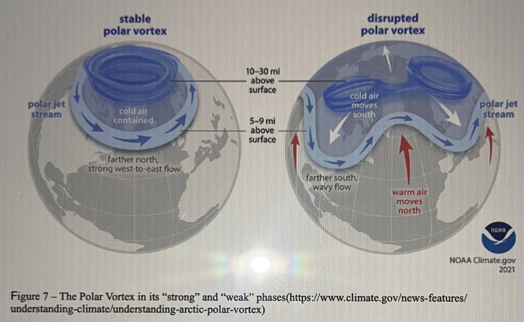
Figure 7 – The Polar Vortex in its “strong” and “weak” phases(https://www.climate.gov/news-features/understanding-climate/understanding-arctic-polar-vortex)
Occasionally, however, it weakens and breaks down, as it did in January/February of 2026 (Figure 8), causing Arctic air to reach as far south as Central America and Southeastern US. Effects were felt as late as April in the Eastern US, as a late spring core of the vortex migrated south, causing unseasonably cold temperatures along the East Coast.
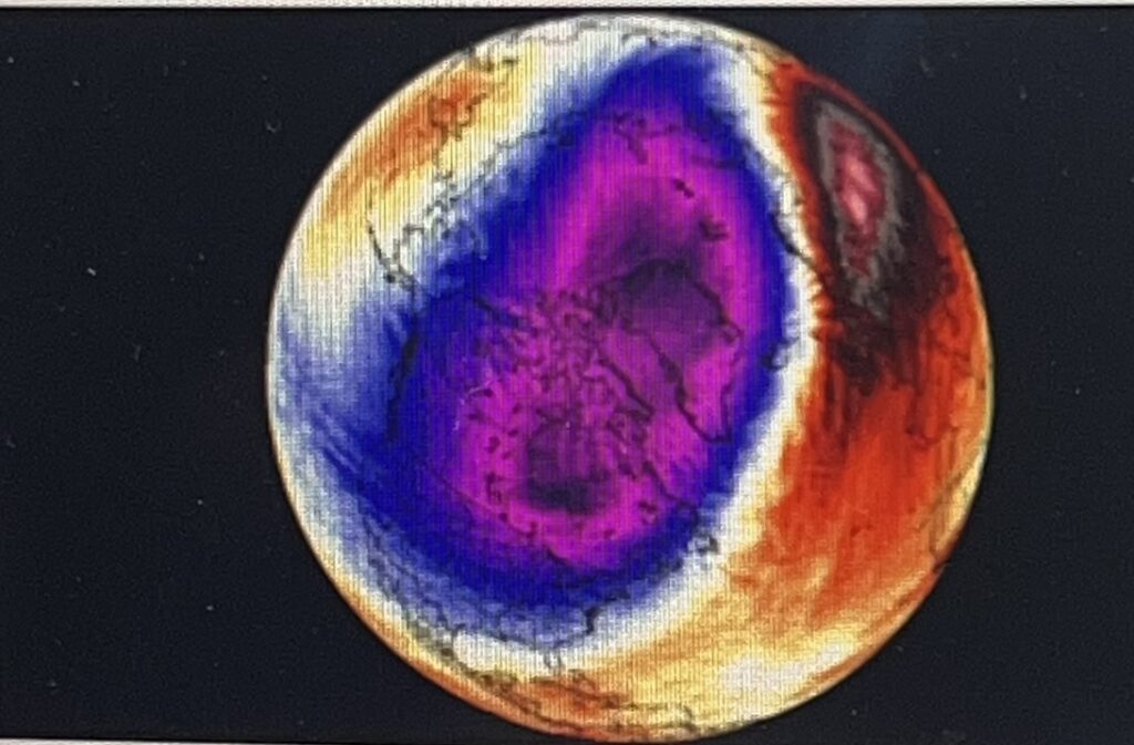
Figure 8 – The Polar Vortex in late January early February 2026. Arctic air mass shown in pink and purple (https://www.severe-weather.eu/global-weather/new-stratospheric- warming january-2026-polar vortex-disruption-cold-united-states-canada-europe-fa/)
In summary, a “classic El Niño” is not what it used to be. And even a “Super El Niño” can still be complicated by what is increasingly becoming the new normal. Warmer-than-average global oceans have taken the edge off the El Niño signal in the Pacific in past years and have disrupted the typical movement of energy and mass in the atmosphere, making it harder for El Niño to deliver on its promise of precipitation to the Southwest US. Add to that the potential complications caused by the MJO and an increasingly unpredictable Polar Vortex and we can expect to see some continued swings in the paradigm.
What does this mean for the Colorado River Basin?
During those periods of time when the MJO is in its “enhancing phase,” with respect to El Niño: we can expect more precipitation in the Southwest U.S. (in the Lower Colorado Basin, certainly, but … how far north into the Upper Basin this might extend is anyone’s guess).
Apart from that, the other complicating factors make it almost impossible to say whether or not El Niño will have a beneficial effect on this year’s snowpack. So far, these factors have kept the snowpack below average Source: Central Arizona Project, Orestes Morfin, Senior Policy Analyst.
2. New York State imposes The Nation’s first statewide moratorium on hyperscale data centers for up to one year as the state devises protections for the environment and its energy grid.
Source: US News https://apnews.com/article/new-york-data-centers-moratorium-ai-c1e05b74208a6c 570eec 7c658ac8f187utm_source=join1440&utm_medium=email&utm_ placement=newsletter& user_id=66c4bace5d78644b3a9105ad
3. How Many Trees Exist On Earth? A Look At The Numbers Behind Our Forests. With all of the forest fires in the U.S., Canada and Europe, it’s difficult to think about all of the trees on our home planet.
While no one has physically counted every trunk and branch, researchers have combined satellite imagery, artificial intelligence, forest inventories, and more than 400,000 ground-based measurements to estimate are number of trees across our planet.
The answer? About 3.04 trillion trees. Roughly 390 trees for every person on Earth. Researchers now emphasize that protecting existing forestsgenerally delivers greater environmental benefits than replacing them later. Mature forests already store enormous amounts of carbon, regulate rainfall, preserve biodiversity, and maintain healthy soils.
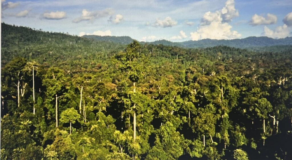
One recent study estimated that offsetting the carbon contained in the fossil fuel reserves of the world’s largest oil, gas, and coal companies through tree planting alone would require an area roughly the size of North and Central America combined Source: Interesting Engineering July 14, 2026 https://interestingengineering.com/culture/how-many-trees-are-on-earth.
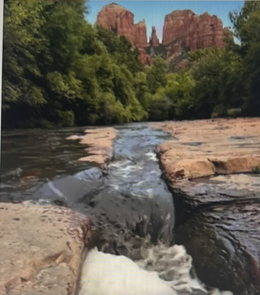
4. Arizona’s Premier Protected Water Is NOT To Be Entered. The crystal waters of Oak Creek have been replaced with black water runoff from the upslope Pocket Fire that burned over 26,000 acres of the Oak Creek watershed.
It is advised that no one and no pets enter the waters until the waters is clear of the ash, burned soil and burned wood that is held in suspension by the fast moving water.
5. Asteroide That Hit New Jersey Home, Tells A Story. At 11:20 a.m.a home in Hillsborough, rudely interrupted its homeowner. “I heard an immense crash and felt the house shake,” he said. It was as if all his kitchen cabinets had suddenly fallen off the walls.
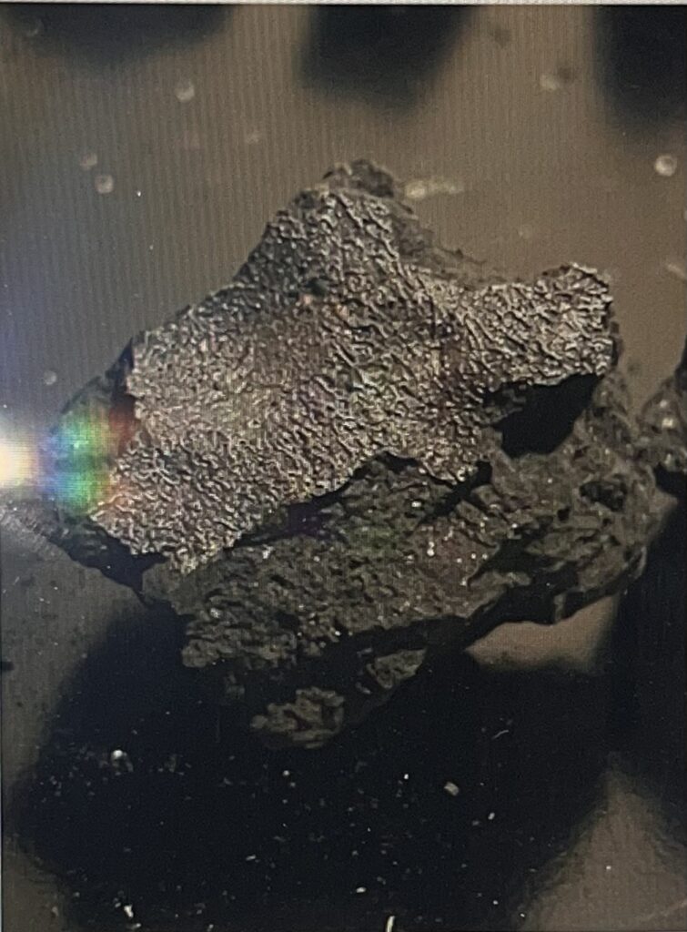
The air smelled like rotten, sulfurous eggs, mingled with a fine dust. There appeared to be black soot on every horizontal and vertical surface. When the owner glanced at his pillow, he saw several onyx-colored rocks.
Now, a new study published on Wednesday in the journal Science Advances reveals that the space rock is no ordinary specimen. It contains complex organic molecules and tantalizing evidence of salty water — ingredients that life, as we know it, thrives on. Asteroids much like the Hillsborough sample may have delivered the same crucial compounds to a newly-formed Earth billions of years ago, said Peter Jenniskens, a planetary astronomer and meteoriticist at the SETI Institute in California, and one of the authors of the new study.
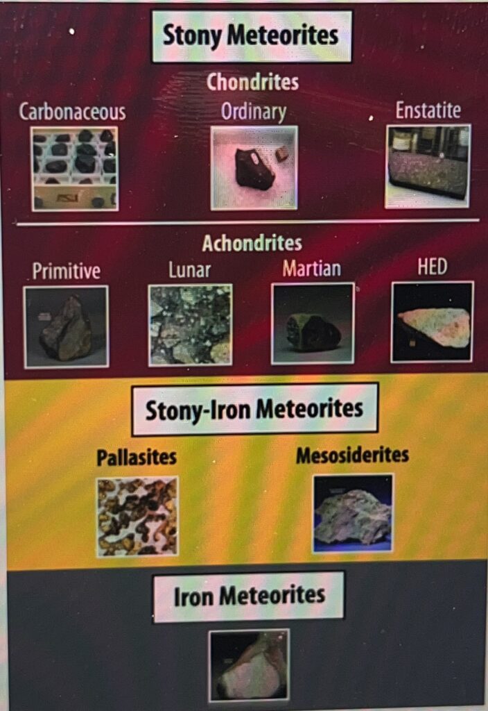
Based on the meteorite’s composition, the trajectory of its fall and the length of its exposure to solar and cosmic radiation while venturing through space, the study’s authors believe it was first part of a huge asteroid named 163 Erigone, that formed in the cold shadows beyond Jupiter. Source: NY Times
Interested in learning about AZ meteorites, check out ArizonaState University’s Buseck Center for Meteorite Studies located on ASU’s campus or online at https://meteorites.asu.edu.
Copyright 2026 @ EnviroInssight.org
