Daniel Salzler No. 1355
EnviroInsight.org Four Items April 25, 2026
—————Feel Free To Pass This Along To Others——————
If your watershed is doing something you would like others to know about, or you know
of something others can benefit from, let me know and I will place it in this Information .
If you want to be removed from the distribution list, please let me know.
Please note that all meetings listed are open.
Enhance your viewing by downloading the pdf file to view photos, etc.
The attached is all about improving life in the watershed through knowledge.
If you want to be removed from the distribution list,
please let me know. Please note that all meetings listed are open.
Check our website atEnviroInsight.org
1. Climas. Taking A Look At Our Climate
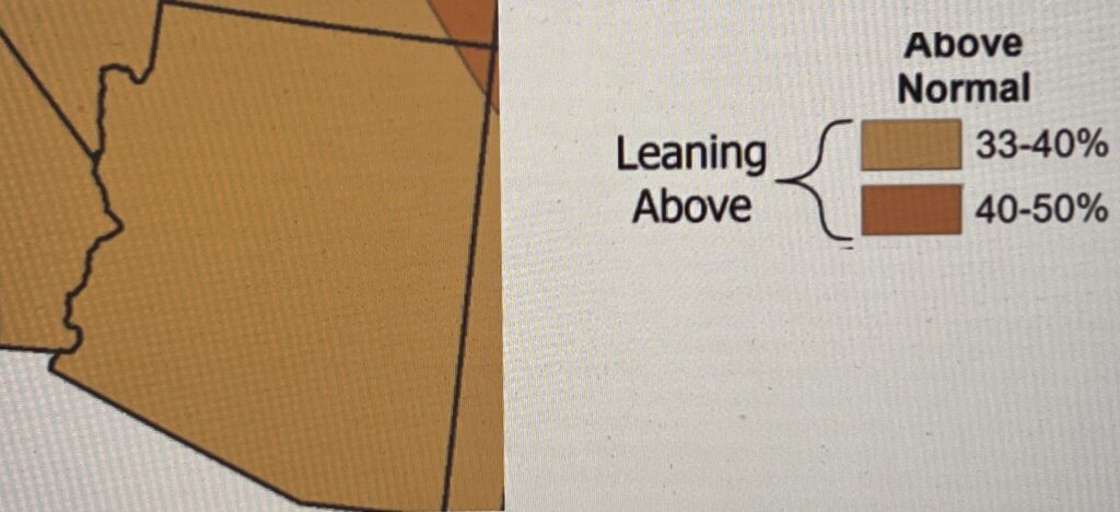
Monthly Temperature. Valid for
May 2026 Issued April 16, 2026
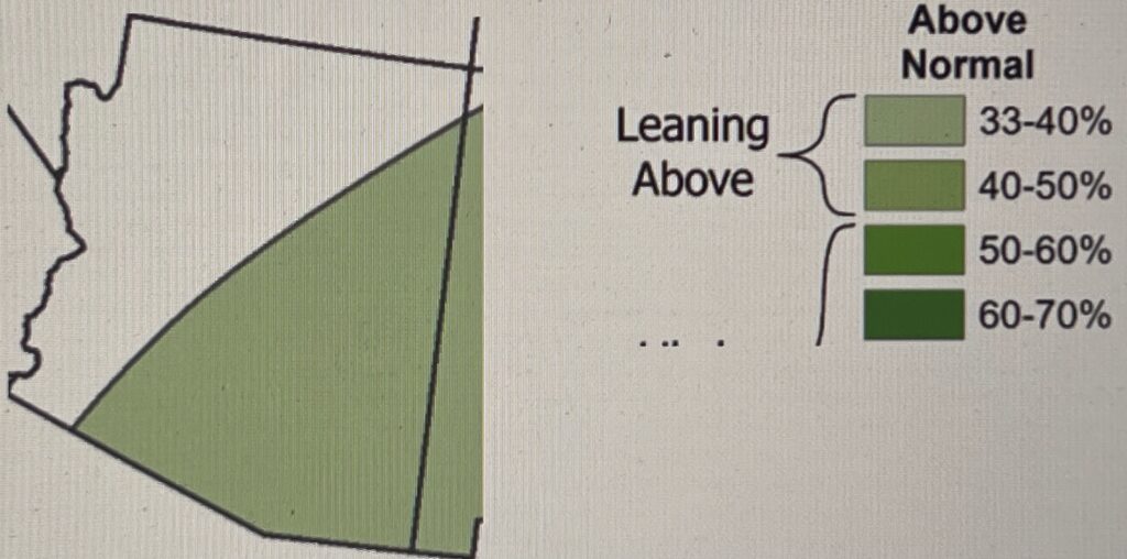
Seasonal Temperature Outlook from May to July
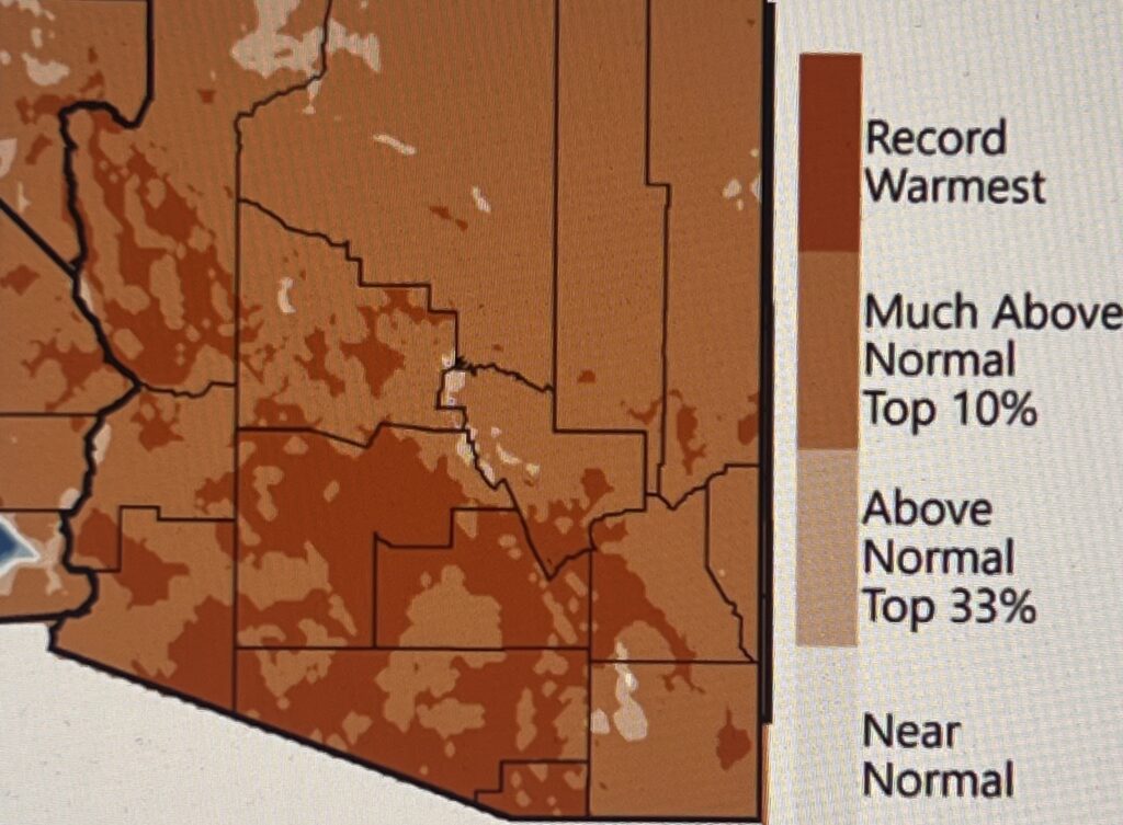
Mean Temperature
February 2026
February temperatures were much above normal (ranking among the warmest 10% of Februarys on record) across Arizona. For parts of southern and western Arizona, it was the warmest February on record.
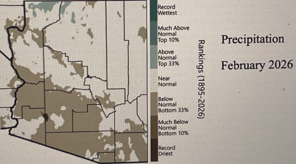
Precipitation
February 2026
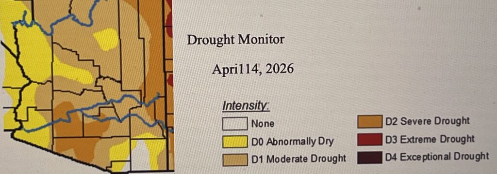
December–February 3-month precipitation totals were below normal or much-below normal across much of Arizona totals were near normal to above normal for parts of southeastern Arizona.
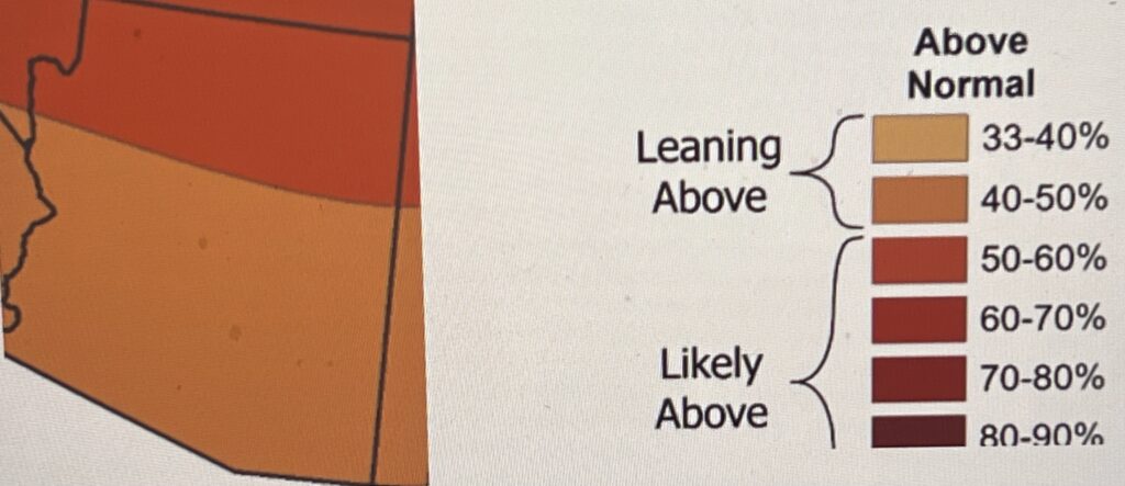
SeasonalPrecipitation Outlook
May to July 2026
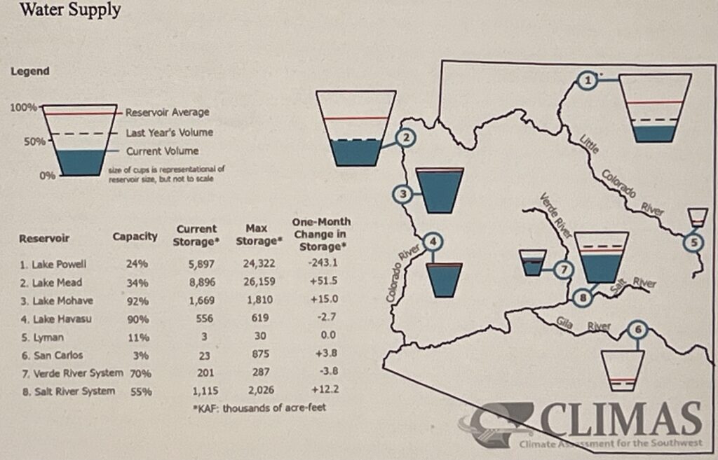
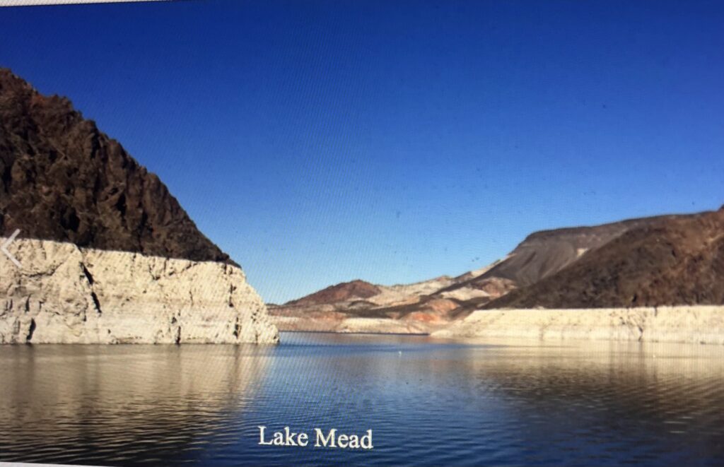
The combined storage of Lake Powell and Lake Mead is down compared to last year and remains far below the long-term average. Salt River and Gila River reservoirs are likewise down compared to last year and the long-term average, but Verde River storage is above normal for this time of year.
Climate’s Influence on Lower Colorado Streamflow
Researchers have long recognized the influence of warming temperatures on streamflow, but the practical implications for water management have received less attention. To address this gap, CLIMAS researchers worked with resource managers in Arizona to shape a research agenda focused on climatic controls on surface water supplies for three key rivers: the upper Gila, Verde, and Salt Rivers. The study found that cool-season precipitation remains the primary driver of annual streamflow. However, the summer monsoon plays a critical role—especially in the upper Gila River basin—by helping to offset the impacts of dry winters and multi-year droughts. The analysis also highlighted the increasing influence of temperature on water supplies, particularly during low-flow years and recent drought periods. These insights were especially valuable for major water utilities like the Salt River Project, which serves the Phoenix metro area. For more information, visit theproject website Source: Climas.com.
2.U.S. To Drastically Alter Colorado River Releases, Arizona Officials Warn. To prop up a declining Lake Powell, the federal government plans to significantly cut Colorado River releases from Powell to Lake Mead and to boost releases from Upper Colorado River Basin reservoirs to Powell, Arizona’s top water officials say.
The measures would be aimed at preventing Lake Powell from falling below the level at which Glen Canyon Dam, which adjoins the lake, would no longer be able to generate electricity that serves more than 5 million people in seven states including Arizona, said a letter from Arizona Department of Water Resources Director Tom Buschatzke and Central Arizona Project General Manager Brenda Burman to a statewide water advisory committee.
The other and perhaps deeper concern about Powell’s falling water levels is that if the lake falls far below the level it can generate power, its ability to deliver river water to Arizona, Nevada and California would also become significantly more limited, perhaps limited enough to eventually trigger major cutbacks in water supplies for Tucson and Phoenix and for the Los Angeles area.
Even now, the reductions in water deliveries from Powell that currently appear to be in the works would significantly reduce the amount of water stored in Lake Mead on the Arizona-Nevada border — water that is delivered to Tucson and Phoenix, as well as other cities in Arizona, Nevada and California, the river’s Lower Basin states.
The reductions now under consideration wouldn’t be severe enough to force additional cuts in water supplies for the Central Arizona Project canal system beyond those the three Lower Basin states have agreed to take starting in 2027, under proposals they’ve submitted to the U.S. Bureau of Reclamation. But it would leave Lake Mead in a much more vulnerable position to receive deeper cuts in the future if 2027 brings another dry year on the river.
Most likely, additional releases of water to Lake Powell, on the Arizona-Utah border, would come mainly from the feds’ Flaming Gorge Dam and Reservoir at the Utah-Wyoming border.
It holds far less water than Lake Powell — 3.6 million acre-feet compared to 23.3 million at Powell.
But Flaming Gorge is much fuller — 82% compared to 24% for Powell. So Flaming Gorge is perceived by many water experts to be a good, short-term source for additional water for the embattled Lake Powell, although the same experts have said its supply is only going to last for a year or two of releases, at most, barring a major change in weather conditions bringing the region more water.
In their letter, Buschatzke and Burman said the bureau initially plans to release up to 1 million acre-feet of river water from Upper Basin reservoirs, including Flaming Gorge.
“That action may begin in about one week and continue through April 2027. Hydrology may force that volume to be reduced to a minimum of 660 acre-feet,” the letter said. It added that a release of a million acre-feet is more in line with what Arizona officials have advocated, “and is a positive outcome.”
Reclamation plans these measures in the face of what the Arizona water officials termed “absymal” winter and spring snowpack in the mountains of the Upper Colorado River Basin and projections for the flows of river water into Lake Powell during the spring and early summer of this year.
“Things are trending towards the lowest runoff on record, perhaps lower than 2002 runoff volume, the lowest year on record,” says Buschatzke and Burman’s April 7 letter, obtained Wednesday by the Star.
The bureau has for some time pledged to do all it can to keep Powell’s water level at least 3,500 feet in elevation — 10 feet above the lowest level at which Glen Canyon Dam’s turbines can generate electricity.
In their letter, Burman and Buschatzke said “we must stress that Reclamation has made no final decision on the actions described above.
The final decision will be made “on or about” this Friday, April 17, when the bureau finalizes its monthly study of the river’s conditions, which projects what levels its reservoirs will be at for the upcoming 24 months, Buschatzke and Burman wrote. The contents of their letter were first reported by E&E News, a website owned by Politico that covers environmental issues.
The bureau, in a recent statement, pledged generally to take steps to prop up the declining lake but offered no specifics.
“Due to increasingly severe hydrologic conditions, it has become necessary to implement additional measures in the near future to ensure Lake Powell remains above the critical elevation of 3,500 feet. This action is essential to protect reliable water delivery, preserve key infrastructure, and maintain flexibility in our operations,” the bureau’s statement said.
As recently as April 6, U.S. Interior Secretary Doug Burgum, whose office oversees Reclamation, said in a public appearance in Tucson that the bureau would soon announce measures for Powell’s sake to be implemented this month.
Water officials of the four Upper Basin states have for years expressed major concerns about the prospect of releasing large amounts of water from Flaming Gorge and other Upper Basin reservoirs. While the Lower Basin officials have said the upstream reservoirs were authorized and built in part to keep Powell amply supplied with water, the Upper Basin states have said this water has now become important for their recreation and other water supply needs and have protested previous upstream reservoir releases.
But in a joint statement last week, the four Upper Basin state governors warned that the states shouldn’t depend too much on Flaming Gorge water to keep Powell operating properly. The Upper Basin states are Colorado, New Mexico, Utah and Wyoming.
“We must have a clear understanding of how these proposed releases will effectively protect elevations at Lake Powell,” they wrote. “Once the releases conclude, we expect that all water released from Flaming Gorge and other upstream reservoirs will be fully recovered.”
Their statement warned that the four Upper basin states already are “actively and strictly” regulating water use.
“This is an unprecedented year on the Colorado River, and likely will be one of the worst on record,” the governors stated. “A dry year like this reminds us of why it is critical that all who rely on this resource learn to live within its means and adapt our uses accordingly.
“Because of such diminished runoff, existing state laws in the Upper Division States require water users to face cuts to water rights dating back to the 1800s — these cuts are mandatory, uncompensated, and will have significant impacts on water users, including Upper Basin Tribes, and local economies.”
This spring marks the second time in four years that officials became concerned about the prospect of Lake Powell falling below the lowest level it can generate electricity.
In spring and summer 2022, both Lake Powell and Lake Mead fell low enough that then-Reclamation Commissioner Camille Touton warned a congressional committee that all seven river basin states needed to make drastic cuts in their use of river water. But in early 2023, the river basin was hit by a major series of snowstorms and heavy rains that dramatically raised reservoir levels, eliminating the short-term threat to the water supplies.
But river flows and reservoir levels have been dropping significantly since then. Powell is now down to 3,526 feet elevation this week, and is projected by the bureau to fall to as low as 3,523 feet by May — about the same level it was at in May 2022. Under the bureau’s most likely scenario, Powell could fall below 3,490 by December 2026, and under a more pessimistic scenario, it could get that low by August 2026.
If electric power is cut off from Glen Canyon Dam, that would almost certainly boost the cost of electricity to the farmers, small cities, tribes and other entities that now buy power from the dam.
And the farther Powell falls below 3,490 feet, the less water officials will be able to run through the dam’s turbines, and the more they’ll have to run through the dam’s outlet works. Those are a series of four steel tubes that can carry large amounts of water, but which most experts agree aren’t designed to carry large amounts of water for long periods.
The fear among many Lower Basin water officials in particular is that reliance on the outlet works would force water deliveries to Arizona, California and Nevada to even lower levels than now expected to be available in the near future. Source: Arizona Daily Star, April 18,2026
3. Upper Agua Fria Watershed Partnership. The Rural Groundwater Resilience Exchange: next meeting is on April 23, from 3:00 -4:30 <ruby@swdresources.com>.
Upper Verde as Outstanding Arizona Water, Comments due, April 14, 2026. UAFWP will submit support. Process started in 2012; strong ADEQ support.
Next Meeting: May 5, 2026, on line at 10 am.
For more information, contact Mary at earthhous@aol.com
4. Celebrate Water Month In April And All Year Long. Only 3% of all the water on earth is fresh and of that, only 0.5% is available for drinking. The remaining 2.5% is either too polluted for use, or locked away in ice captors and glaciers.
- Use a really good water filtration system for your home
- Drink water on-the-go originating from your home, in non-plastic containers.
- Wash/rinse dishes as you fill the sink
- Wipe pots and pans
- Do NOT run water while you brush your teeth
- Consider installing a rain barrel to collect rain (if you live where it rains once in a while)
- Water lawns and gardens for longer periods of time, less frequently (deep watering = good)
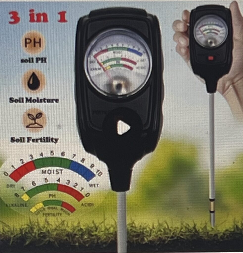
- Use soil moisture meter to determine when your plants need water
- Use a brush or broom to clean our driveway or outdoor furnishings so as to avoid flushing pollutants down the drain and into our rivers and streams .
- Use a carwash to clean your car. Water used at crashes is recycled many times.
- And many, many additional activities that will save water or provide means to consume clean water and not contaminate water.
4. Celebrate Water Month In April And All Year Long. Only 3% of all the water on earth is fresh and of that, only 0.5% is available for drinking. The remaining 2.5% is either too polluted for use, or locked away in ice captors and glaciers.
Use a really good water filtration system for your home
Drink water on-the-go originating from your home, in non-plastic containers.
Wash/rinse dishes as you fill the sink
Wipe grease, oil and fats from pots and pans with paper towels and toss towels into trash
Do NOT run water while you brush your teeth
Consider installing a rain barrel to collect rain (if you live where it rains once in a while)
Water lawns and gardens for longer periods of time, less frequently (deep watering = good)
Use soil moisture meter to determine when your plants need water
Use a brush or broom to clean our driveway or outdoor furnishings so as to avoid flushing pollutants down the drain and into our rivers and streams .
Use a carwash to clean your car. Water used at crashes is recycled many times.
And many, many additional activities that will save water or provide means to consume clean water and not contaminate surface or ground water.
Copyright 2026 @ EnviroInsight.org