1. Intermountain West Climate Dashboard

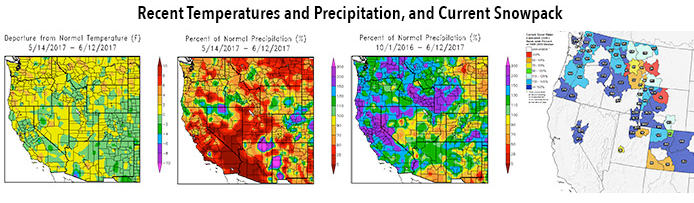
- The latest monthly briefing was posted today on the Intermountain West Climate Dashboard. The highlights, also provided below, cover current snowpack and drought conditions, forecasted spring-summer streamflows, recent temperatures and precipitation, and ENSO and precipitation outlooks.
- With below-normal or near-normal snowpack conditions and very low antecedent soil moisture, NOAA’s January 1 forecasts call for much-below-average (50-70%) or below-average (70-90%) spring-summer runoff across nearly all of the region’s basins. Unless there is significant improvement in snowpack conditions, most of the basins in Colorado and Utah that saw very low runoff in 2018 will face another year of hydrological drought.
- After a mostly dry December, and a somewhat better start to January, snowpack conditions are overall slightly below normal for the region and for each state. As of January 14, most basins in Colorado, Utah, and Wyoming are reporting between 85- 105% of normal SWE. Southwestern Colorado is still the driest area with 75-80% of normal SWE, though this is improved from mid-December. The SNOTEL basin average for the Upper Colorado River Basin is at 90% of normal.
- NOAA CBRFC’s official January 1 seasonal runoff forecasts, along with those of the neighboring RFCs, call for much-below-average (50-70%) or below-average (70-89%) spring-summer runoff for the vast majority of forecast points in Colorado, Utah, and Wyoming. Near-average (90-110%) runoff is forecasted for several points in northcentral Colorado and in the Arkansas Basin. The CBRFC January 1 forecast for Lake Powell April-July inflows is for 64% of average (4.55 MAF). The outlook for forecasted flow across the region is worse than the snowpack conditions alone would indicate, which mainly reflects the very low antecedent soil moisture in fall 2018 in most basins. (NRCS did not produce January 1 runoff forecasts due to staffing constraints.)
- December was generally drier than normal across the region, aside from well-aboveaverage precipitation in parts of central Utah, southwestern Colorado, and northeastern Wyoming , with near-normal temperatures prevailing over the region . In the first two weeks of January, a series of storms have left wetter-than-normal conditions over southern and central Colorado, southeastern Utah, and central and northeastern Wyoming, with dry conditions elsewhere.
- Since early December, drought conditions have seen little change across the region. The area of exceptional drought (D4) in the Four Corners region saw a smidgen of improvement. Abnormally dry (D0) conditions expanded slightly in northeastern Colorado after the very dry December there.
- El Niño-ish? ENSO indicators have almost reached the multi-month thresholds for declaration of El Niño conditions, though the warm anomalies in the tropical Pacific have weakened in the last month. If an El Niño event does officially and finally emerge, as is still likely, it will be weak and unlikely to persist past the spring. The CPC seasonal precipitation outlooks for the January-March and February-April periods still show slightly enhanced chances for above-normal precipitation for Colorado and adjoining states, consistent with historical tendencies during El Niño events.
View the Intermountain West Climate Dashboard on the Western Water Assessment website.
2. Do You Have A Dog? Is He/She Healthy?
According to world famous veterinarian, Dr. Martin Goldstein, one out of one point six one dogs eating regular dog food will develop and probably die from a tumor. If you are interested in keeping you dog healthy, feed them a regular diet of organ meats, omega-3’s and Prebiotics (flax, carrots, ginger). Check out Dr. Marty’s website to order his 100% guaranteed food or for more information go online to www.drmartysnaturalfoods.
3. Upper Agua Fria Watershed Meeting.
Upper Agua Fria Watershed Partnership meets Tuesday March 5, 10 am at Maricopa Water District. Agenda to follow.
4. Water Rights Battle Over Gila River Could Kill Drought Contingency Plan.
A battle is brewing over valuable water rights that could blow up Arizona’s Drought Contingency Plan.
Legislative House Speaker Rusty Bowers has proposed overturning a state law requiring farmers upstream from the Gila River to use their water share every five years or lose it.
He plans to argue that the long standing law does not consider years when flooding destroys crops and fields leaving farmers struggling to use their allotted water.
The Gila River Community has engaged in a series of legal battles with farmers over the years, Bowers claimed.
“They are destroying people who don’t have a $20 million retainer,” he said. “They don’t have the assets to do the fight.”
In some cases, he said farmers have been in as many as six lawsuits over the water rights, “and it’s just killing them.”
But, the Gila River Indian Community’s Attorney Don Pongrance said Bowers bill essentially allows the farmers to “steal” the water from the tribe and it undermines a more than century old water rights act.
“It essentially says to us, ‘no, you’re really not part of Arizona because those of us who control what happens in Arizona get to make the rules and change the rules on you so you lose your water rights,” Pongrance said.
Pongrance warned Bowers’ bill will force the Gila River Indian Community to reject the drought contingency plan, which the Bureau of Reclamation has given the state until the end of the month to approve or face coming up with an alternate plan.
5. You Probably KnowThat The Milk You Drink Is BSE-free. What Does This MeanTo You And Your Family?
BSE is short fort Bovine Spongiform Encephalopathy, sometimes referred to as “mad cow disease”, is a chronic degenerative disease affecting the central nervous system of cattle. The disease belongs to the group of transmissible spongiform encephalopathies, which also includes scrapie of sheep and goats and chronic wasting disease (CWD) of elk and deer (known as Creutzfeldt-Jakob’s disease).
A system of strong interlocking safeguards protects human and animal health, as well as food safety, in the United States. These safeguards include the removal of specified risk materials (SRMs) – those tissues that may contain the BSE agent in an infected animal – from the human food chain.
Inspectors from USDA’s Food Safety and Inspection Service (FSIS) also prevent nonambulatory disabled cattle from entering the human food supply. In addition, they prevent certain slaughter practices that might present a risk of transmission of BSE. FSIS inspectors also condemn any cattle that display clinical signs of neurological disease or central nervous system disorders. To prevent the disease’s transmission to people, the single most important food safety measure is to avoid human consumption of SRMs. Inspectors in every slaughterhouse in the United States work to ensure these and other food safety standards are met.
Once thought to just infect elk and deer, BSE was found in a cow in California in 2012. Before this latest detection, USDA had diagnosed three cases of BSE in the United States – the first in December 2003 in a cow imported from Canada to Washington State, and two subsequent cases with cows born and raised in the United States – one in Texas and one in Alabama. USDA scientists have identified and characterized all three of the BSE cases, using various laboratory diagnostic methods. These include internationally accepted procedures for histopathology, immunohistochemistry, and the Western blot.
Bovine spongiforin encephalopathy is the only known zoonotic Transmissable Spongifor develops even among lifelong vegetarians.’ Consumption of contaminated meat can cause personality changes, anxiety, depression, memory loss, blurred vision, insomnia, jerky movements and difficulty swallowing
Hunters of elk and deer should use caution when bringing carcass’s to your home.
Sources: USDA and JAVMA, Vol 234, No 1, January 1, 200
6. Momentum Is Growing to Defend the Arctic Refuge.
Since the day congressional Republicans passed legislation opening up the coastal plain of the Arctic National Wildlife Refuge for drilling, we’ve known that it would be an uphill battle to defend this sacred place from the Trump administration and their greed-fueled plans to sell it out to corporate polluters. But over the last few months, from public hearings to corporate boardrooms to Capitol Hill, momentum is growing on the side of keeping this special place protected.
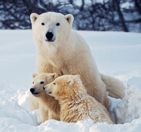
Late last week, the Sierra Club reported some exciting news in the fight to defend the Arctic Refuge from oil exploration. At a public hearing in Alaska, officials with the Department of the Interior confirmed that the destructive seismic testing will not take place in the coastal plain of the Arctic National Wildlife Refuge winter. The refuge is safe for this winter
This is a really big deal. Seismic testing isn’t just the first step toward drilling; it would do significant damage before a single drill rig is even permitted. It would mean bringing in industrial vehicles and equipment to the sensitive coastal plain, threatening wildlife including denning mother and baby polar bears, and leaving permanent scars on the landscape. Since a small company called SAExploration put in its application to do this destructive exploration, we’ve been keeping up the pressure to stop it. More than 250,000 people have sent emails and called SAExploration’s offices and executive board urging them to drop their proposal. In January, we supported the Gwich’in Steering Committee and local Indigenous advocates in a powerful action to hand deliver boxes containing 100,000 of those letters to the company’s office in Houston. Source: NY Times
7. Globe City Council Declines Its Share Of CAP Water.
While the Globe City Council voted unanimously last week to decline its share of extra Central Arizona Project (CAP) water, it nonetheless plans to revisit the issue soon.
In his Nov. 29, 2018 letter to Globe Mayor Al Gameros, San Carlos Apache Tribal Chairman Terry Rambler said the Tribe plans to lease 5,925 acre-feet of its CAP water to the Town of Gilbert each year, for up to 100 years, at a price of $5,267.21 per acre-foot.
One acre-foot of water equals 325,851 gallons, or the amount of water needed to cover an acre of land a foot deep.
In his letter, Rambler cited the Dec. 16, 1999 San Carlos Apache Water Rights
Settlement Agreement, which gives the City of Globe the right of first refusal for the extra CAP water.
Prior to offering — or accepting an offer — to lease or otherwise transfer all or part of its CAP water supplies to another municipality, the Tribe must first offer Globe 980 acrefeet per year, under the same terms and conditions as the other municipality.

Once the Tribe makes its offer in writing, Globe has 90 days with which to accept or decline.
In his presentation at the Jan. 8 council meeting, Globe City Manager Paul Jepson recommended that the council decline buying any San Carlos water at the offered price of $5,267.21 per acre foot.
Each year, Globe has elected not to accept the extra water, as it has maintained an adequate supply, he said.
Jepson said that Rambler asked Globe to expedite the decision “as best we could,” so that the Tribe could complete its agreement transferring water rights to Gilbert.
He also recommended that the council direct the city attorney to draft a response letter, signed by Gameros on behalf of the council, and send it to Rambler at the earliest opportunity. Source: Arizona Silver Belt
8. OSHA 8 hour Refresher. Know anyone needing to take his/her 8-Hour OSHA class?
If you or someone you know are in need in an 8-hour refresher class, let me know. For $80, you’ll receive a great eight hours of instruction, a continental breakfast and lunch. Call Dan at 623-930-8197.
9. Making Beer.
When making home-made beer, are male, female or either hop plants used to make beer.
10. The Bill Williams River: Where Did It Get Its Name? The Bill Williams River , a tributary to the lower Colorado River, was a major travel corridor for Native Americans, European Explorers and early settlers. The river gets its name from a missionary-turned mountain-man who traveled throughout Arizona in the early 1800s. Legend has it he is buried in an unmarked grave somewhere on Bill Williams Mountain near Williams.
Answer to No. 9 Female