Daniel Salzler No. 1152
EnviroInsight.org Three Items June 3, 2022
—————Feel Free To Pass This Along To Others——————
If your watershed is doing something you would like others to know about, or you know of something others can benefit from, let me know and I will place it in this Information newsletter.
If you want to be removed from the distribution list, please let me know.
Please note that all meetings listed are open.
Enhance your viewing by downloading the pdf file to view photos, etc. The
attached is all about improving life in the watershed. If you want to be removed from
the distribution list, please let me know. Please note that all meetings listed are open.
Check our website at EnviroInsight.org
1. Upper Agua Fria Watershed Partnership
June 7, 2022, 10 am
Mingus Springs Camp on Mingus Mountain; see map ———>
Draft Agend
1. Introductions and Announcements
2. Thanks to Henry Dahlberg for hosting;
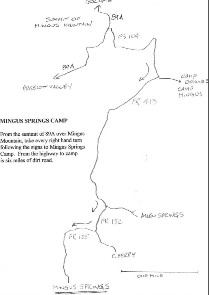
Introduction to Mingus Springs
3. Arizona Mtals Black Canyon City
Kay Mine
a. Community Meeting May 23, 2022 – report
b. Natural Riparian Resources Inventory; Yavapai County GIS (Supervisor Gregory Tony Angueira, BLM inventories (Roger Joos)
4. Solar Farm Proposals: Officially Candela
chosen: UAFWP role now?
5. ADOT <improvingi17.com>. Water Sources
for Construction; updates: Supervisor Gregory letter
to ADOT; Dave Moore communication
2. Comparing Two Mighty Rivers: Colorado VS Mississippi
| Colorado River | Mississippi River | |
| Watershed Size | 246,000 square miles | 1,151,000 square miles |
| Length of River | 1450 miles | 2,340 miles |
| Amount of water moving Down the River | Near Lee’s Ferry – 1.333 million gps | 1.6 million gps |
| Landscape along the river | 1,000 miles of deep gorges | Watershed Info No 1152 Relatively flat to rolling hills |
| States touched by the river | Wyoming, Colorado, Utah, New Mexico, Nevada, Arizona and California | Minnesota, Wisconsin, Iowa, Illinois, Missouri, Kentucky, Tennessee, Arkansas, Mississippi, and Louisiana, Koroa |
| Rivers, streams, creeks that flow to the river | 103 | 7,000 |
| Area drained by the river | 246,000 sq.mi. | 1.2 million sq.mi |
| Area first inhabited | 12,000 yrs ago by Clovis and Folsom cultures | Settled around 1,000 BC Choctaw, Koroa, Taensa Chickasaw, Tunica, Yazoo Pascagoula, Natchez, Biloxi, Alibamu and Illinois |
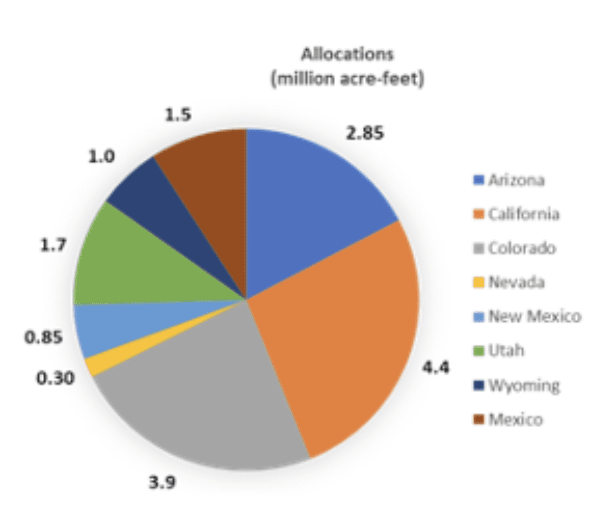
| Water apportioned to states | The Upper Colorado River Basin Compact, which apportioned use of the Upper Basin waters among them. The compact permits Arizona to use 50,000 acre-feet of water annually from the upper Colorado River system, and apportioned the remaining water to the Upper Basin States in the following percentages: Colorado, 51.75 percent; New Mexico, 11.25 percent; Utah, 23 percent; and Wyoming, 14 percent. The Lower Basin States of Arizona, California and Nevada were not able to reach agreement. In 1952, Arizona filed suit in the United States Supreme Court to determine how the waters of the Lower Basin should be divided. In October 1962, the court ruled that of the first 7,500,000 acre-feet of mainstream water in the Lower Basin, California is entitled to 4,400,000 acre-feet, Arizona 2,800,000 acre-feet, and Nevada, 300,000 acre-feet. The United States has contracted with the States of Arizona and Nevada and with various agencies in Arizona and California for the delivery of Colorado River water. These contracts make delivery of the water contingent upon its availability for use in the respective States under the Colorado River Compact and the Boulder Canyon Project Act. | ll states east of Texas, with the exception of Mississippi, follow what is known as the riparian doctrine. Riparian law traditionally grants certain ownership rights to anyone whose land has frontage on a body of water. Typical riparian rights include the use of the entire surface of a body under the condition that such use is reasonable and does not interfere improperly with the rights of other riparian owners on on the same body of water. It also includes the right to build piers, docks, landings and wharves; and to participated in fishing, boating, hunting, and the irrigation of crops. It can also allow the owner the right to consume reasonable amount of water. |
3. First-EverTier 1 Shortage For Colorado River Water For 2022: What Does Residents And Businesses. In January of 2022 with the release of the Bureau of Reclamation (BOR)’s August 24-Month Study. For many years Arizona water professionals have been anticipating and preparing for this shortage. So what does this mean for Arizona residents?
Arizona is located in both the Upper and Lower Colorado River Basins.

A series of dams and canals in the Colorado River system provide storage for regional water supply, facilitate water deliveries, provide flood control benefits, and generate hydroelectric power. A series of Federal laws known as the “Law of the River” have been established which allocate water rights from the Colorado River to seven U.S. states, including Arizona, California, Colorado, Nevada, New Mexico, Utah, and Wyoming as well as parts of northern Mexico.
Water rights totaling of 16.5 million acre-feet (maf) were allocated to the seven U.S. States and Mexico based on an average annual natural flow rate of 18.0 maf in the Upper Basin; however the average annual natural flow rate in the Upper Basin from 1906 – 2015 was about 14.8 maf.
When the rights were originally granted, the over allotment of water rights was not an issue as the supply was greater than the demand; however, due to rapid growth in these regions, the demand now exceeds the supply. In response to the increased demand on water resources, in 2019 the seven U.S. States signed the DCP.
The DCP is a set of agreements designed to protect the Colorado River system through voluntary reductions and increased conservation and is implemented according a tiered system which is based on the water level in Lake Mead (one of the two largest reservoirs in the Colorado River System). Based on the January 1st projected water level in Lake Mead of 1,065.85 feet above sea level, the U.S. Secretary of the Interior has declared the first-ever Tier 1 shortage for Colorado River operations in 2022.
What This Means for Arizona
Arizona receives approximately 36% of its water supply from the Colorado River. Much of the water from the Colorado River is conveyed throughout central and southern Arizona by the Central Arizona Project (CAP). The Tier 1 shortage will require a 0.512 maf reduction in Arizona’s water consumption from the Colorado River; accounting for approximately 30% of CAP’s normal supply; approximately 18% of Arizona’s total Colorado River supply; and approximately 8% of Arizona’s total water use.
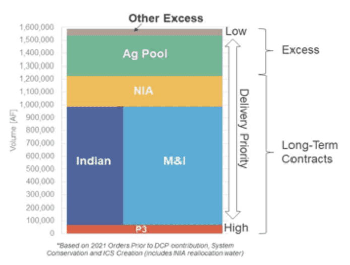
Who will be affected by the Tier 1 shortage depends on priorities. In 2019, 72% of water consumption in Arizona was from agricultural use, 22% was from municipal use, and 6% was from industrial use. The highest priority water is given to some of the large irrigation districts in Yuma and elsewhere on the mainstem of the Colorado River, termed Third Priority (P3). The second highest priority is sharded by the long-term contracts held by municipalities and industry (M&I) and Native American tribal lands. Third priority was allocated to tribes, cities and towns in a group termed “Non-Indian Agricultural” (NIA). The lowest priority is given to uses labeled as excess; which is any water available to CAP after satisfying the long-term contracts.
Who will be affected by the Tier 1 shortage depends on priorities. In 2019, 72% of water consumption in Arizona was from agricultural use, 22% was from municipal use, and 6% was from industrial use. The highest priority water is given to some of the large irrigation districts in Yuma and elsewhere on the mainstem of the Colorado River, termed Third Priority (P3). The second highest priority is sharded by the long-term contracts held by municipalities and industry (M&I) and Native American tribal lands. Third priority was allocated to tribes, cities and towns in a group termed “Non-Indian Agricultural” (NIA). The lowest priority is given to uses labeled as excess; which is any water available to CAP after satisfying the long-term contracts.
Certain agricultural districts relinquished their long-term water entitlements as part of the 2004 Arizona Water Settlements Act. In exchange for giving up their long-term rights, the irrigation districts were given access to a lower-cost fixed volume of even lower priority water. Access to this Agricultural Settlement Pool (Ag Pool) water expires in 2030. It is the Ag Pool group which will be most affected by the Tier 1 shortage.
The Future for Arizona
The Colorado River Basin has been experiencing a prolonged drought since the year 2000. The ertain agricultural districts relinquished their long-term water entitlements as part of the 2004 Arizona Water Settlements Act. In exchange for giving up their long-term rights, the irrigation districts were given access to a lower-cost fixed volume of even lower priority water. Access to this Agricultural Settlement Pool (Ag Pool) water expires in 2030. It is the Ag Pool group which will be most affected by the Tier 1 shortage.
The Future for Arizona
The Colorado River Basin has been experiencing a prolonged drought since the year 2000. The 2020 projected water level in Lake Mead was 1089.4 feet above sea level and in 2022 the projected water level is 1,065.85 feet above sea level, a loss of 23.55 feet over two years. The water elevation below which triggers Tier 2 shortage measures is 1,050 feet above sea level. The conservation and reduction measures enacted by the Tier 1 shortage declaration are intended to slow the loss of water from the Lake Mead Reservoir. If the drought in the Colorado River Basin persists, additional reductions to CAP water users are likely to occur. If Tier 2 or Tier 3 reductions occur, would impact the CAP water currently available to some central Arizona municipalities and tribes.
2020 projected water level in Lake Mead was 1089.4 feet above sea level and in 2022 the projected water level is 1,065.85 feet above sea level, a loss of 23.55 feet over two years. The water elevation below which triggers Tier 2 shortage measures is 1,050 feet above sea level. The conservation and reduction measures enacted by the Tier 1 shortage declaration are intended to slow the loss of water from the Lake Mead Reservoir. If the drought in the Colorado River Basin persists, additional reductions to CAP water users are likely to occur. If Tier 2 or Tier 3 reductions occur, would impact the CAP water currently available to some central Arizona municipalities and tribes.
This ruling has far-reaching effects, yet in Arizona it may affect how your ability to secure water rights or impact the site selection process for any new construction. This could also cause certain municipalities to rely more heavily on groundwater as their primary water source. Water which is drawn from the aquifer will be treated and recharged to the aquifer after use. This could cause those municipalities to implement more strict wastewater effluent limits to prevent groundwater contamination.
If you have any questions about how this reduction may impact your facility or how Trinity Consultants can assist with recommendations, please email Thaddeus Bahl in the Phoenix office.
Copyright: Enviroinsight.org
Copyright: EnviroInsight.org 2022