Watershed Info
Daniel Salzler No.1089
EnviroInsight.org Three Items February 5, 2021
—————Feel Free To Pass This Along To Others——————
If your watershed is doing something you would like others to know about, or you know of something others can benefit from, let me know and I will place it in this Information newsletter.
If you want to be removed from the distribution list, please let me know.
Please note that all meetings listed are open.
Enhance your viewing by downloading the pdf file to view photos, etc. The attached is all about improving life in the watershed. If you want to be removed from the distribution list, please let me know. Please note that all meetings listed are open.
Enhance your viewing by downloading the attached pdf file to view photos, etc.
The attached is all about improving life in the watershed.
Read this newsletter at EnviroInsight.org
1. Impacts Of Wildfire On Water Quality And Water Treatment. Since 2010, Wildfires have burned more that 67 million acres in the United States. In 2020 alone (as of September). More than seven million acres have burned, and 3.7 million acres were actively burning. Of those, 117,000 acres were in Colorado, according to the National Interagency Fire Center. These fires have impacted water quality and created treatment challenges for water utilities.
A wildfire’s path of destruction is not limited to things that burn – water is at risk too. When fires jump from forests and grasslands to urban areas, they incinerate household and industrial items such as computers and cars, leaving behind a stew of chemicals and heavy metals. Rain can wash this into streams, rivers and municipal water treatment systems unprepared to deal with the toxic deluge. Heavy sediment loads from wildfire-related erosion can also clog water systems and strain treatment requirements.
The challenges aren’t limited to fire-prone regions. Ash and smoke particles can carry harmful chemicals hundreds, if not thousands, of miles. Even the way we fight fires can taint our water, a fact made clear this past April when chemical-laden retardants apparently killed hundreds of fish in Berkeley, California. While the retardants had not been used to fight a wildfire, studies have shown commonly used fire retardants can be lethal to aquatic life.As an appointee to the San Francisco Regional Water Quality Control Board, Newsha Ajami has worked with local, state and federal agencies to monitor and ensure water quality in areas affected by wildfires. Ajami is director of urban water policy at Stanford’s Water in the West program, and co-leads the Urban Water Systems & Institutions Thrust at Re-Inventing the Nation’s Urban Water Infrastructure(ReNUWIt), a National Science Foundation engineering research center based at Stanford. She discussed wildfire’s threat to water quality with Stanford Report
What are some of the potentially dangerous ways that wildfire can affect water quality?
When wildfires reach urban areas, they burn houses, cars, restaurants and stores which are all full of electronics, appliances, solar panels, industrial chemicals, batteries, paint and plastic, to name a few. If fire debris is not fully cleaned up, it can be flushed and transported into water bodies by rain. We hope for a rainstorm to help us contain the fire, but that rain can flush fire debris into water bodies. In addition, these fires can burn water infrastructure such as water distribution pipes, potentially cutting off access to clean water.
What are the implications for water-dependent agricultural crops and products?
Unless you cover all your crops and hope for the best, there’s no way to prevent ash and smoke from getting into the soil and impacting its chemical properties. Plants can absorb these pollutants directly through their leaves and roots, potentially affecting their growth or making them unsafe for consumption. In case of high-value crops, these chemicals can change the taste – as can be the case with grapes, for example – and it can impact sales, of course. It’s less of an issue for water-based beverage companies. They purify their water, and most people don’t think about the water source for their beer or other drinks anyway. So, it would probably take a serious PR mistake for wildfire impacts on a water source to affect sales of beer or other beverages. Either way, there’s a lot we don’t know about chemicals that make their way from wildfire debris into crops, so it remains an area of concern that needs to be studied.
What can we do to guard against wildfire impacts on water sources?
Active forest management, especially in the areas at the wildland-urban interface. We can install sediment barriers and take other measures to prepare for wildfire’s effects, but such measures can be expensive and labor intensive.

The most important thing is to clean up debris from burned urban areas before they are washed into waterways. You need crews with heavy equipment, time and the funding to do that. It is hard to predict how an intense wildfire would spread since it depends on so many factors. However, we need to incorporate more innovative thinking in our design process and incorporate more nature-based solutions and flexible systems, such as wetlands, open spaces and riparian areas, to slow fire expansion and related water pollution.
What do we need in terms of new policies, guidelines, etc.? We need to rethink how we do water treatment in light of limited understanding about long-term consequences of exposure to fire-related chemicals in the water system. We need to evisit guidelines on water-related infrastructure in fire-prone areas. We need new guidelines on monitoring strategies after fires in order to track and understand both short-term and long-term cumulative water quality impacts. Also, we need to develop innovative funding and financial models and tools, such as bonds that enable public-private partnerships to address pressing environmental issues, including forest management and urban development in light of climate change and shrinking federal and state funding.The main focus, however, should be fire prevention. Building cities and communities to be more fire-resilient requires the will of the people and legislators. That’s not there now since these kind of fires are a new phenomenon and we are still trying to wrap our heads around it.
So the focus has been mostly on disaster recovery. Also, current funding models make it so that money for prevention and cleanup are accessible only at specific times – not necessarily the most logical or advantageous times, since the more we spend on prevention, the less we need to spend on post-disaster management.
What are some of the important gaps in our understanding about how wildfire affects water?
The water quality impacts of wildfires on the urban-wildland interface are still not fully understood and investigated. This type of fire is a more recent phenomenon mostly exacerbated by climate change and its effect on intensity of extremes. We need more active short-term and long-term monitoring designed for fire-related metals and toxins. We need to investigate how ash and smoke plumes can affect water and soil in other regions beyond the fire zone.
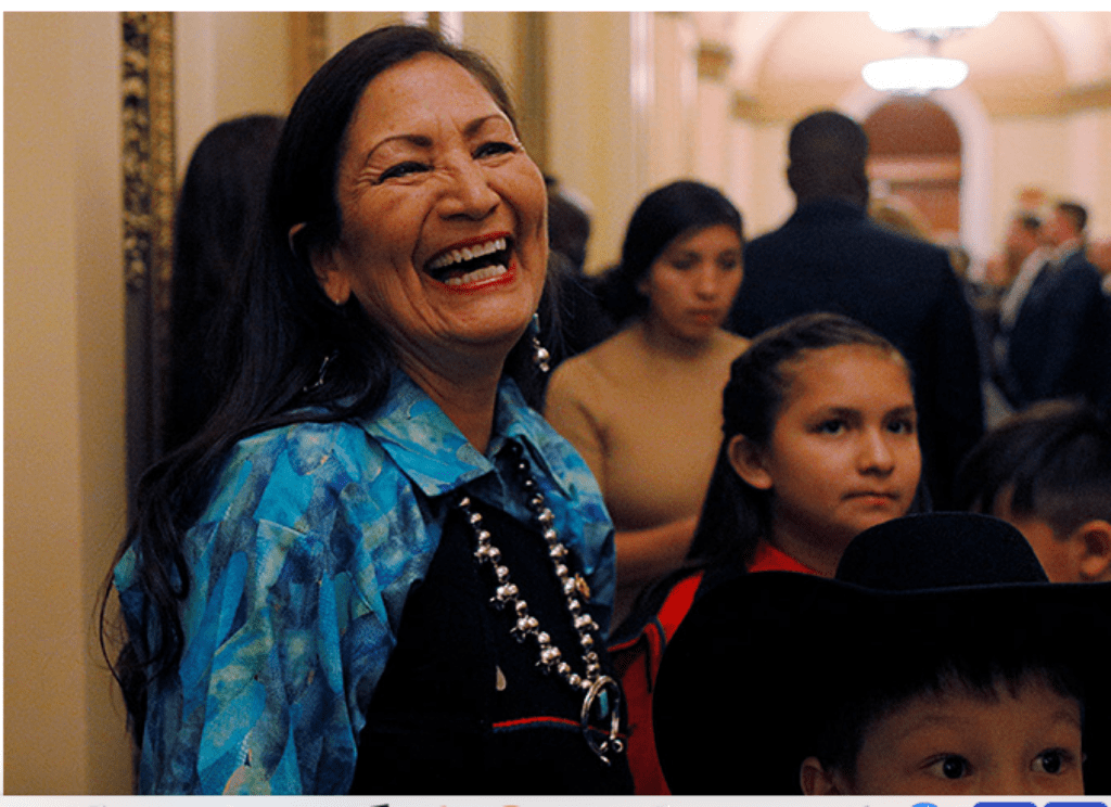
2. Tribes Expect A Voice On Land And Waters Under Haaland With Democratic New Mexico Rep. Deb Haaland poised to become the first Native American Interior secretary, tribal governments historically marginalized by the agency expect not only a greater respect for their autonomy, but also a more significant role in the nation’s land and water management decisions.
Tribes aren’t a monolith, frequently pushing different — and sometimes competing — agendas. But tribal leaders and experts have identified common issues they expect Haaland to act on quickly if confirmed, including an overarching need for better consultation and recognition of tribal sovereignty across Interior’s wide authority over lands and waters.
“There’s been a lot of neglect” of tribal programs, said Raina Thiele, an Obama administration official. “Haaland coming in as secretary begins to right the ship in terms of balance of focus of the department.”
Thiele served as former President Obama’s associate director of intergovernmental affairs and public engagement, working with tribes, Native organizations and Alaska Native corporations.
At Interior, the top job has been typically held by “a series of folks who are either experts in environmental issues and conservation issues or folks who are experts and really care deeply about fossil fuels, extractive industry, depending on which party is in power,” said Thiele, an Alaska Native.
“That is what has led to this neglect to this very core part of what the Department of Interior is,” she added.
As a possible example of the changed approach, Thiele pointed to an executive order President Biden signed last week recognizing tribal sovereignty and self-governance, while also directing agencies to establish “regular, meaningful, and robust consultation” with tribal nations (E&E News PM, Jan. 26). University of Colorado law professor Sarah Krakoff, who is known for her work in Native American and environmental justice issues, said she expects Haaland, a member of the Pueblo of Laguna in New Mexico, to deploy innovative options for tribal consultation, including co-management of some public lands.
“I think some of the things we can anticipate include a robust approach to gathering tribal nations’ feedback and views and thoughts about projects that are not only on tribal lands but that affect tribal sacred sites and tribal natural resources,” Krakoff said.
Interior’s Bureau of Indian Affairs oversees more than 56 million acres of land in trust for both tribes and individuals. Those lands include 326 sites, known as reservations, pueblos and rancherias, among other monikers. The Navajo Nation’s reservation marks the largest unit, at about 16 million acres.
But other lands, like the Bears Ears National Monument, where multiple tribes claim important spiritual and cultural ties, are managed by other divisions of the Interior Department, including the Bureau of Land Management.
“It is an opportunity to start fresh because it seems like this administration understands the equal value and the complementary value of respecting tribal sovereignty and self-determination,” Krakoff added. “Many tribal nations want more influence because they have long histories of being good stewards of their lands.”
A poor legacy
Haaland’s landmark nomination could also begin restoring a historically troubled past of exploiting Native American lands.
Interior’s Bureau of Indian Affairs, for example, was originally housed in the Department of War, and Indigenous communities were frequently considered wards of the state.
“Those policies they had set at the beginning still have a lot of influence in the way tribal consultation works, the way land management works, the way water management works and how Indian Affairs work,” said Julia Bernal of the Pueblo Action Alliance in New Mexico.
That colonization “has exploited resources, exploited labor, disenfranchised Indigenous and Black communities of color,” she said.
Haaland, Bernal added, “is assuming a federal agency that has a really, for lack of a better term, shitty legacy.”
Haaland’s own agenda will likely look to shore up the consultation process with tribes before undertaking federal actions on tribal lands or waters.
During the Trump administration, many tribes felt ignored, said Shannon Wheeler, the chairman of the Nez Perce Tribe in the Pacific Northwest. That consultation process is required under federal treaties, but often, it is perfunctory, he said.
“Consultation with federal agencies is honored and at the highest level, and it’s not just a check-the-box process,” Wheeler said. “Under the former administration, it seemed to be that.”
The consultation requirement applies to a broad range of activities that would be within Haaland’s purview at Interior, from oil and gas leasing and permitting to public lands management and endangered species mitigation.
A recent report from the liberal Center for American Progress said the government has “largely failed” to manage public lands in a manner consistent with its tribal treaty obligations, calling most consultations “feeble.”
“We want those consultations to be meaningful to put treaty rights and inherent rights where they should be,” 12id. “That federal agencies take that trust responsibility seriously.”
The tribes have some reason for optimism. In addition to the recent executive order, Biden issued a plan on the campaign trail that pledged to “provide tribes with a greater role in the care and management of public land that are of cultural significance to Tribal Nations.”
While Haaland awaits a date for her own confirmation hearings, the Biden administration is also moving ahead with key Interior hires, including Natalie Landreth as deputy solicitor for land. Landreth, a citizen of the Chickasaw Nation of Oklahoma, joins the agency from the Native American Rights Fund, where she spent 17 years (Greenwire, Feb. 3).
“I’m optimistic based upon the campaign promises that [Biden] made to the tribes, just hoping for the best,” NARF Executive Director John Echohawk told E&E News before Landreth’s new post was announced.
3. Capturing Climate-Change Data – sometimes It IS Rocket Science. Sometimes it’s easiest to see the effects of climate change from above – way above.
3. Capturing Climate-Change Data – sometimes It IS Rocket Science. Sometimes it’s easiest to see the effects of climate change from above – way above.
Thanks to a $1 million grant from NASA’s Earth Science Division, an interdisciplinary team of researchers from Arizona State University’s School of Sustainable Engineering and the Built Environment has been working with Central Arizona Project on a comprehensive evaluation of climate and land-use changes and how these impact the Colorado River Basin. And, now, NASA’s Earth-observing satellites – as well as ground data from the US Geological Survey, the National Oceanic and Atmospheric Administration and other entities – is starting to generate more data that will help in future Colorado River Basin modeling.
Stakeholders are reviewing this data to decide how it can be most valuable. The research team for this study, known as the “Long-Range Scenario Modeling of the Colorado River Basin Project” has identified Collaborative Modeling and Discussion Groups (Co-Mods) focused on using the satellite data for a model set-up and testing phase, analyzing scenarios and disseminating project results. Source: CAP

The five initial project Co-Mods proposed by the research team are:
- Selection of climate models for use in scenario planning
- Land cover change scenarios for non-urban areas
- Useful metrics to summarize model outcomes
- Value of remote sensing products for model evaluations
- Landscape survey of active and relevant research in the Colorado River Basin
In addition to CAP and ASU, involved stakeholders include:
- Arizona Department of Water Resources
- Colorado Department of Natural Resources
- Colorado River Board of California
- Colorado River District
- Colorado Water Conservation Board
- Denver Water
- Metropolitan Water District of Southern California
- New Mexico Interstate Stream Commission
- Southern Nevada Water Authority
- Upper Colorado River Commission
- U.S. Bureau of Reclamation
- Utah Division of Water Resources
- Wyoming State Engineer’s Office
Ultimately, this data will be used to analyze the impacts of climate change on the Colorado River and in turn, to inform future decisions regarding the future of the Colorado River as a major water supply to the West. This includes decisions by the Arizona Reconsultation Committee, which is developing an Arizona perspective on the reconsultation of the Colorado River Interim Guidelines for Lower Basin Shortages and the Coordinated Operations for Lake Powell and Lake Mead, known as the 2007 Guideline.
EnviroInsight.org 2021
Stakeholders are reviewing this data to decide how it can be most valuable. The research team for this study, known as the “Long-Range Scenario Modeling of the Colorado River Basin Project” has identified Collaborative Modeling and Discussion Groups (Co-Mods) focused on using the satellite data for a model set-up and testing phase, analyzing scenarios and disseminating project results. Source: CAP