1. Attract Native Wildlife To Your Garden. Plan to attend a free class on how to attract beneficial wildlife to your garden at the Glendale Main Library, located at 5959 W Brown Street on Wednesday October 16 from 6:00 to 7:30 p.m.
Register at (623) 930-3760 or [email protected]. For additional information on the class, go to www.glendaleaz.com/waterconservation.

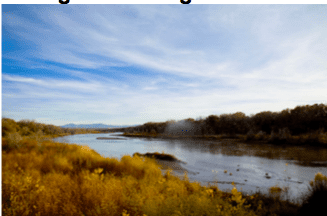
2. Notice of Availability: Upper Santa Cruz River Clean Water Plan The final draft of the Upper Santa Cruz River Clean Water Plan is now available. The draft waste load and load allocations, along with ADEQ’s response to comments, were published in the Arizona Administrative Register (AAR) on August 2, 2019.
Upper Santa Cruz River Subwatershed Clean Water Plan for E. coli Santa Cruz River
Reach 1(505) 030-1009: Nogales International WWTP outfall to Josephine Canyon Reach 1(505) 030-1008 A: Josephine Canyon to the Tubac Bridge Reach 1(505) 030-1008 B: Tubac Bridge to Sopori Wash Nogales Wash Reach 1(505) 030-1011: US/Mexico border to Potrero Creek Potrero Creek Reach 1(505) 030-1500 B: Below Interstate 19 to the Santa Cruz River https://static.azdeq.gov/wqd/swqip/user_cwp.pdf
3. WaterSMART Cooperative Watershed Management Program Phase I Grants
Go online to CWMP Phase I FOAFINAL_0911 19_508 for additional information and requirements

4. Solid and Hazardous Waste and Pollution Prevention Workshop in Flagstaff
Arizona Department of Environmental Quality (ADEQ) Waste Programs Division invites interested community members and business and government personnel to participate in our free workshop. Don’t miss this opportunity to learn about the latest requirements and best practices and to earn Professional Development Hours.
Wednesday, Sep. 25 Solid Waste, Hazardous Waste and Pollution Prevention 9 a.m. – 12:30 p.m.
Coconino County Community Services and Health Services District, Ponderosa Conference Room – 2625 N King St, Flagstaff Learn more and register at azdeq.gov
5. UA-led Study Measures Impact of Built Environment on Water Use Research shows housing density, lot size and other built environment measures are closely tied with water use in single-family residences. Authors say the data can help growing cities plan for their future water supply needs.
How much water single-family residences use is closely related to a community’s built environment, according to a University of Arizona-led study. In particular, design factors such as vegetated land cover, housing density and lot size appear to have a strong impact on water use.
The results can provide key data for city planners and water managers looking to develop sustainable water use strategies for their communities, the authors suggest in the paper that was published today in the Journal of the American Planning Association.
Philip Stoker, assistant professor in the UA College of Architecture, Planning and Landscape Architecture, and a team of researchers focused on how water use is influenced by the built environment, which Stoker defines as “the way cities take shape – what the materials are made out of, what the land cover consists of, the arrangement of buildings and what kind of buildings are there.”
The team obtained single-family residential property water-use records from 2011 in Phoenix; Salt Lake City; Portland, Oregon; and Austin, Texas. Researchers estimated models for both annual water use and water use during the summer months of June through August. The cities were selected because they each offer insights relative to the impacts of both climate change and rapid urban population growth on residential water consumption. Single-family residences are the principal form of residential development in each city and make up a large share of overall water use.
“As cities, especially in the Western U.S., continue to grow, planners need to think about their water supplies moving into the future,” said Stoker, whose co-authors included thengraduate student Gabrielle Jehle, Elizabeth Wentz and Brint Crow-Miller of Arizona State University, and Matthew Bonnette of Portland State University. “With this study, we wanted to give them information to develop a strategy. We wanted to show how the planning and design of cities influence how water is used.”
City Design is Key
The researchers examined the influence of five built environment measures on singlefamily residential water use: housing density, tax assessed value, lot size, vegetative cover and the age of housing. They found in each city, the built environment poses a stronger influence on urban water use than previously reported.
“In Austin, for example, we were able to explain 85% of the variation in water use among Austin neighborhoods with just the five measures of the built environment,” Stoker said.
Some measures impacted water use across the board. The researchers found increased vegetated cover, combined with larger lots, in newer homes, with higher assessed values, were associated with higher water use in each city.
Vegetated cover was associated with an increased water demand more than any other built-environment variable in the drier cities. The effect was greatest in Salt Lake City, where each 1% increase in average vegetated surface was tied to a 0.48% increase in annual water use and a 0.7% increase in summer use.
Higher housing density was associated with lower water use in every city except Salt Lake City, where the measure was not statistically significant.
Surprises in the Data
Stoker says researchers had expected lot size to be a consistent predictor of water use. However, those findings varied across the four cities.
In Austin and Portland, larger lots were associated with higher water use. In Austin, a 1% increase in lot size was associated with an approximate 0.32% increase in summer water use. Lot size was not significantly associated with annual or summer water use in Salt Lake City, and there was an inverse relationship in Phoenix, with larger lot size tied to lower water use.
Stoker says he was also surprised by the findings on the age of housing, as the expectation was that newer housing would be associated with lower water use because of higher-efficiency appliances. However, the opposite was true in Austin, Portland and Salt Lake City. The association was strongest in Salt Lake City, where, for every 1% increase in housing age there was an approximate 0.31% decrease in annual water use and about 0.33% decrease in summer use.
Planning for Water Efficiency
Stoker says city planners and water managers can use the data to work together on developing zoning ordinances, form-based codes and landscaping ordinances that can lead to more efficient water usage. Regulations could, for example, specify smaller lot sizes for future developments, or call for reduced or different types of vegetated cover on single-family properties. In implementing these regulations, Stoker says, city leaders must balance factors such as whether the water-use reduction outweighs the benefit vegetated land has on temperature-cooling efforts.
6. Things to Know About Rattlesnakes and Their Babies
Arizona’s rattlesnakes welcome their offspring in July and August. While baby rattlesnakes are small, their bite is just as dangerous.
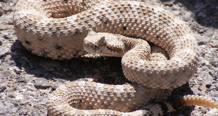
Arguably, snake season is year-round in Arizona, a state known for its rattlers. But baby rattlesnakes are born in July and August, making these two months especially dangerous for hikers, gardeners, children and others at high risk of exposure to rattlesnake bites.
So far this year, 74 rattlesnake bites to humans have been reported to the Arizona Poison and Drug Information Center. Based at the University of Arizona College of Pharmacy, the center serves the entire state of Arizona with the exception of Maricopa County, providing free and confidential poison and medication information to callers around the clock.
Specialists answering the phones at the center regularly receive calls from Arizonans of all ages who don’t realize they were bitten by a rattler. The poison center urges anyone who feels a mysterious sting, pinch or bite while outdoors to immediately call the center at (800) 222-1222.
“We will ask a few questions that will help you either identify possible snakebite or eliminate it,” said Keith Boesen, director of the Arizona Poison and Drug Information Center. “With snakebite, the sooner the medical treatment, the better the outcome, so calling us right away can make a very big difference for the victims and the medical teams treating them.”
The center advises anyone who might come cross paths with rattlesnakes to be aware of these five things:
- | Baby rattlesnakes range in length from 6 to 12 inches and are easily camouflaged by brush and grass.
- | Baby rattlesnakes are rattleless until they first shed their skins, so there will be no infamous “chica-chica” sound before they strike.
- | Despite their impish size, baby snakes have enough venom to be very dangerous if they bite a human.
- | Adult rattlesnakes do not always rattle an audible warning before or while they are biting.
- | It’s a good idea to call the poison center if you notice an unidentified small cut or wound, even if you feel no pain. With the lack of telltale rattle warning, people can be bitten without knowing what has happened until they notice their symptoms and attribute them to a snakebite.
Source: UofA News
7. New Border Wall Could Further Deplete Groundwater Supplies. Organ Pipe Cactus National Monument encompasses more than 330,000 acres of Sonoran desert, and has been designated a UNESCO biosphere reserve. As those protected designations indicate, it’s an incredibly valuable swath of desert landscape for native plants and animals. A stone’s throw from the U.S.-Mexico border lies a large pond, fed from the nearby Quitobaquito Springs.
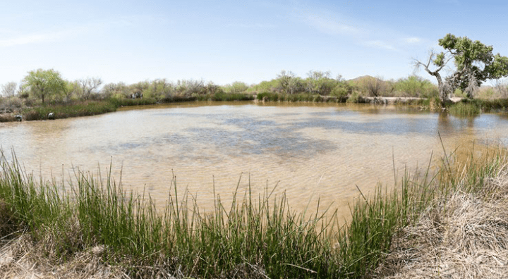
“It’s been a stable source of water for thousands of years,” said Michael Bogan, an aquatic ecologist and assistant professor at the University of Arizona who has worked in the area for several years. The Hia-Ced O’odham and Tohono O’odham have used it as a place to live and essential water source for a very long time, he said.
And desert dwellers don’t have to be told that seeps like this, especially this size, aren’t common.
“It’s essentially the only stable, reliable water in all of the western Sonoran Desert,” Bogan said. Quitobaquito’s location makes it a critical stopover for species migrating back and forth across the border. The springs and pond, and the nearby Rio Sonoyta in Mexico, are also home to a couple of endangered native species found nowhere else in the world. Bogan said because of that, people on both sides of the border have worked to keep as much water in the system as possible.
“We’ve heard from numerous sources, including the Department of Homeland Security, that they plan on drilling wells to suck up groundwater in order to mix concrete for the border wall,” said Laiken Jordahl with the Center for Biological Diversity. His group is suing the current administration over its suspension of dozens of environmental and cultural resource laws related to the new border wall project. Jordahl says they’ve estimated how much water the project will need.
“So, for a mile of border wall we’re talking about almost half a million gallons of water. And here DHS is proposing to build 68 miles of wall in Arizona. And when you total that up, that is not an insignificant number,” Jordahl said.
Jordahl visited Organ Pipe last week and said he spotted what appeared to be a drilling rig operating near Lukeville, and also received reports of drilling activity near Quitobaquito Springs.
Arizona law requires all groundwater wells to be registered and authorized with the state prior to drilling. However no state notification is required to use existing wells unless the use changes.
And the water levels at Quitobaquito may soon only matter to U.S.-based wildlife, because if the 30-foot-high wall gets built, nearly all animals south of the border will no longer be able to reach the pond. Source: Arizona Public Media